You are here: Home > Network List > G - GEOSCOPE Stations List
> Station RER Riviere de l'Est, La Reunion (Indian Ocean) > Earthquake Result Viewer
RER Riviere de l'Est, La Reunion (Indian Ocean) - Earthquake Result Viewer
| Earthquake location: |
South Sandwich Islands Region |
| Earthquake latitude/longitude: |
-55.6/-29.9 |
| Earthquake time(UTC): |
2000/11/07 (312) 00:18:04 GMT |
| Earthquake Depth: |
10 km |
| Earthquake Magnitude: |
6.7 MS, 6.8 MW, 6.6 MW |
| Earthquake Catalog/Contributor: |
WHDF/NEIC |
|
| Network: |
G GEOSCOPE |
| Station: |
RER Riviere de l'Est, La Reunion (Indian Ocean) |
| Lat/Lon: |
21.16 S/55.75 E |
| Elevation: |
834 m |
|
| Distance: |
70.4 deg |
| Az: |
98.846 deg |
| Baz: |
216.899 deg |
| Ray Param: |
0.0550289 |
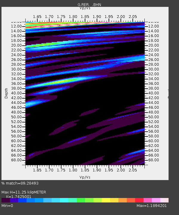
| Estimated Moho Depth: |
11.25 km |
| Estimated Crust Vp/Vs: |
1.74 |
| Assumed Crust Vp: |
4.73 km/s |
| Estimated Crust Vs: |
2.714 km/s |
| Estimated Crust Poisson's Ratio: |
0.25 |
|
| Radial Match: |
89.28493 % |
| Radial Bump: |
400 |
| Transverse Match: |
53.209255 % |
| Transverse Bump: |
400 |
| SOD ConfigId: |
3744 |
| Insert Time: |
2010-02-26 23:44:34.850 +0000 |
| GWidth: |
2.5 |
| Max Bumps: |
400 |
| Tol: |
0.001 |
|
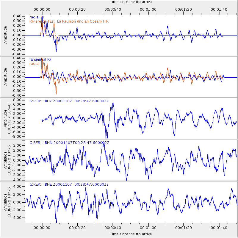
Signal To Noise
| Channel | StoN | STA | LTA |
| G:RER: :BHN:20001107T00:28:47.600002Z | 1.4318577 | 7.679242E-7 | 5.363132E-7 |
| G:RER: :BHE:20001107T00:28:47.600002Z | 1.0779647 | 1.0552321E-6 | 9.789115E-7 |
| G:RER: :BHZ:20001107T00:28:47.600002Z | 1.6284766 | 1.4567615E-6 | 8.9455483E-7 |
| Arrivals |
| Ps | 1.8 SECOND |
| PpPs | 6.4 SECOND |
| PsPs/PpSs | 8.2 SECOND |


