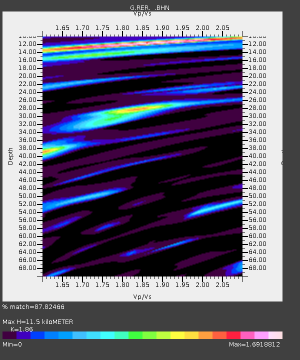
RER Riviere de l'Est, La Reunion (Indian Ocean) - Earthquake Result Viewer
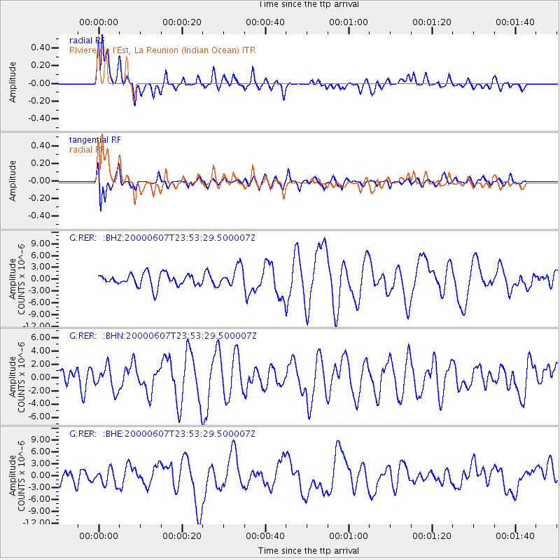
Earthquake location: Southern Sumatra, Indonesia
Earthquake latitude/longitude: -4.6/101.9
Earthquake time(UTC): 2000/06/07 (159) 23:45:26 GMT
Earthquake Depth: 33 km
Earthquake Magnitude: 6.1 MB, 6.7 MS, 6.7 MW, 6.5 MW
Earthquake Catalog/Contributor: WHDF/NEIC
Network: G GEOSCOPE
Station: RER Riviere de l'Est, La Reunion (Indian Ocean)
Lat/Lon: 21.16 S/55.75 E
Elevation: 834 m
Distance: 47.7 deg
Az: 245.552 deg
Baz: 76.454 deg
Ray Param: 0.06976575
Estimated Moho Depth: 11.5 km
Estimated Crust Vp/Vs: 1.86
Assumed Crust Vp: 4.73 km/s
Estimated Crust Vs: 2.543 km/s
Estimated Crust Poisson's Ratio: 0.30
Radial Match: 87.82466 %
Radial Bump: 400
Transverse Match: 70.81176 %
Transverse Bump: 400
SOD ConfigId: 3744
Insert Time: 2010-02-26 23:44:36.095 +0000
GWidth: 2.5
Max Bumps: 400
Tol: 0.001

Signal To Noise

ChannelStoNSTALTA
G:RER: :BHN:20000607T23:53:29.500007Z1.48160371.8044614E-61.217911E-6
G:RER: :BHE:20000607T23:53:29.500007Z1.27661571.937733E-61.5178672E-6
G:RER: :BHZ:20000607T23:53:29.500007Z1.62189942.5699064E-61.5845042E-6
Arrivals
Ps2.2 SECOND
PpPs6.7 SECOND
PsPs/PpSs8.9 SECOND