You are here: Home > Network List > G - GEOSCOPE Stations List
> Station RER Riviere de l'Est, La Reunion (Indian Ocean) > Earthquake Result Viewer
RER Riviere de l'Est, La Reunion (Indian Ocean) - Earthquake Result Viewer
| Earthquake location: |
New Ireland Region, P.N.G. |
| Earthquake latitude/longitude: |
-4.5/153.7 |
| Earthquake time(UTC): |
2000/11/16 (321) 05:51:51 GMT |
| Earthquake Depth: |
33 km |
| Earthquake Magnitude: |
5.8 MB |
| Earthquake Catalog/Contributor: |
WHDF/NEIC |
|
| Network: |
G GEOSCOPE |
| Station: |
RER Riviere de l'Est, La Reunion (Indian Ocean) |
| Lat/Lon: |
21.16 S/55.75 E |
| Elevation: |
834 m |
|
| Distance: |
95.8 deg |
| Az: |
248.302 deg |
| Baz: |
97.058 deg |
| Ray Param: |
0.040674526 |
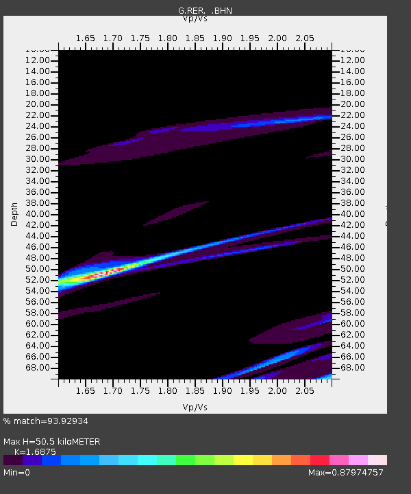
| Estimated Moho Depth: |
50.5 km |
| Estimated Crust Vp/Vs: |
1.69 |
| Assumed Crust Vp: |
4.73 km/s |
| Estimated Crust Vs: |
2.803 km/s |
| Estimated Crust Poisson's Ratio: |
0.23 |
|
| Radial Match: |
93.92934 % |
| Radial Bump: |
283 |
| Transverse Match: |
78.31712 % |
| Transverse Bump: |
278 |
| SOD ConfigId: |
3753 |
| Insert Time: |
2010-02-26 23:44:38.132 +0000 |
| GWidth: |
2.5 |
| Max Bumps: |
400 |
| Tol: |
0.001 |
|

Signal To Noise
| Channel | StoN | STA | LTA |
| G:RER: :BHN:20001116T06:04:42.548997Z | 1.75012 | 9.801279E-6 | 5.600347E-6 |
| G:RER: :BHE:20001116T06:04:42.548997Z | 1.466886 | 7.1222414E-5 | 4.8553477E-5 |
| G:RER: :BHZ:20001116T06:04:42.548997Z | 1.716334 | 3.486248E-5 | 2.031218E-5 |
| Arrivals |
| Ps | 7.4 SECOND |
| PpPs | 28 SECOND |
| PsPs/PpSs | 36 SECOND |


