You are here: Home > Network List > TA - USArray Transportable Network (new EarthScope stations) Stations List
> Station L36A Harm Buss Farm, Glidden, IA, USA > Earthquake Result Viewer
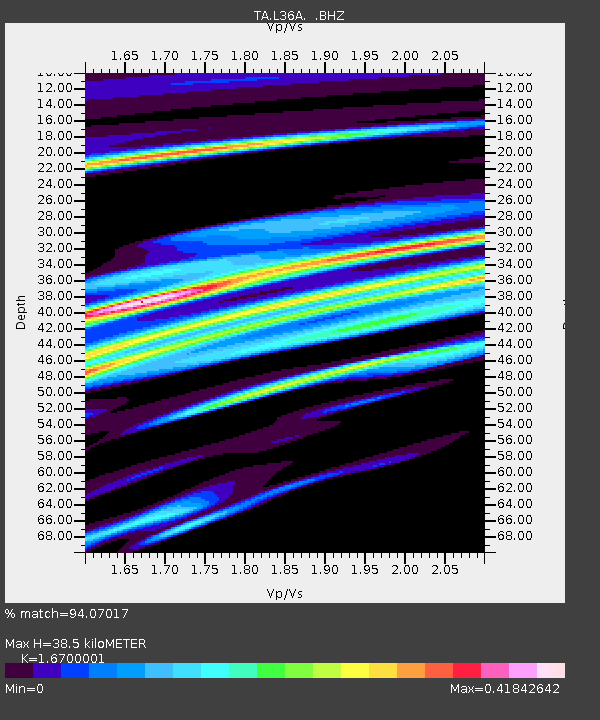
L36A Harm Buss Farm, Glidden, IA, USA - Earthquake Result Viewer
| Earthquake location: |
Norwegian Sea |
| Earthquake latitude/longitude: |
73.0/5.7 |
| Earthquake time(UTC): |
2012/05/24 (145) 22:47:46 GMT |
| Earthquake Depth: |
10 km |
| Earthquake Magnitude: |
5.7 MB, 6.1 MS, 6.1 MW, 6.2 MW |
| Earthquake Catalog/Contributor: |
WHDF/NEIC |
|
| Network: |
TA USArray Transportable Network (new EarthScope stations) |
| Station: |
L36A Harm Buss Farm, Glidden, IA, USA |
| Lat/Lon: |
42.10 N/94.67 W |
| Elevation: |
353 m |
|
| Distance: |
53.2 deg |
| Az: |
293.919 deg |
| Baz: |
21.233 deg |
| Ray Param: |
0.06625074 |
| Estimated Moho Depth: |
38.5 km |
| Estimated Crust Vp/Vs: |
1.67 |
| Assumed Crust Vp: |
6.53 km/s |
| Estimated Crust Vs: |
3.91 km/s |
| Estimated Crust Poisson's Ratio: |
0.22 |
|
| Radial Match: |
94.07017 % |
| Radial Bump: |
400 |
| Transverse Match: |
84.20861 % |
| Transverse Bump: |
400 |
| SOD ConfigId: |
446234 |
| Insert Time: |
2012-08-25 21:22:12.255 +0000 |
| GWidth: |
2.5 |
| Max Bumps: |
400 |
| Tol: |
0.001 |
|

Signal To Noise
| Channel | StoN | STA | LTA |
| TA:L36A: :BHZ:20120524T22:56:34.175Z | 10.568596 | 1.002364E-6 | 9.484363E-8 |
| TA:L36A: :BHN:20120524T22:56:34.175Z | 3.430264 | 4.1093028E-7 | 1.1979553E-7 |
| TA:L36A: :BHE:20120524T22:56:34.175Z | 1.9972494 | 2.3660758E-7 | 1.18466716E-7 |
| Arrivals |
| Ps | 4.2 SECOND |
| PpPs | 15 SECOND |
| PsPs/PpSs | 19 SECOND |


