You are here: Home > Network List > G - GEOSCOPE Stations List
> Station RER Riviere de l'Est, La Reunion (Indian Ocean) > Earthquake Result Viewer
RER Riviere de l'Est, La Reunion (Indian Ocean) - Earthquake Result Viewer

| Earthquake location: |
Southern India |
| Earthquake latitude/longitude: |
23.4/70.2 |
| Earthquake time(UTC): |
2001/01/26 (026) 03:16:40 GMT |
| Earthquake Depth: |
16 km |
| Earthquake Magnitude: |
6.9 MB, 8.0 MS, 7.7 MW, 7.7 ME |
| Earthquake Catalog/Contributor: |
WHDF/NEIC |
|
| Network: |
G GEOSCOPE |
| Station: |
RER Riviere de l'Est, La Reunion (Indian Ocean) |
| Lat/Lon: |
21.16 S/55.75 E |
| Elevation: |
834 m |
|
| Distance: |
46.5 deg |
| Az: |
198.776 deg |
| Baz: |
18.467 deg |
| Ray Param: |
0.07058944 |
| Estimated Moho Depth: |
12.5 km |
| Estimated Crust Vp/Vs: |
1.88 |
| Assumed Crust Vp: |
4.73 km/s |
| Estimated Crust Vs: |
2.513 km/s |
| Estimated Crust Poisson's Ratio: |
0.30 |
|
| Radial Match: |
92.11205 % |
| Radial Bump: |
314 |
| Transverse Match: |
83.04923 % |
| Transverse Bump: |
400 |
| SOD ConfigId: |
3744 |
| Insert Time: |
2010-02-26 23:44:41.690 +0000 |
| GWidth: |
2.5 |
| Max Bumps: |
400 |
| Tol: |
0.001 |
|
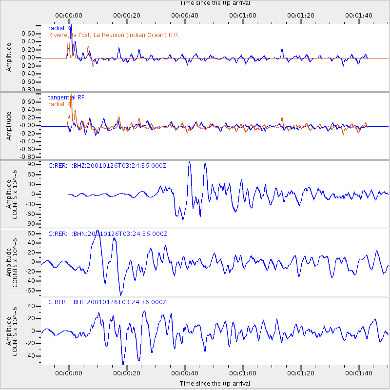
Signal To Noise
| Channel | StoN | STA | LTA |
| G:RER: :BHN:20010126T03:24:36.000Z | 3.4269702 | 9.737349E-6 | 2.841387E-6 |
| G:RER: :BHE:20010126T03:24:36.000Z | 1.3200245 | 4.538056E-6 | 3.4378575E-6 |
| G:RER: :BHZ:20010126T03:24:36.000Z | 4.377609 | 1.4935274E-5 | 3.4117425E-6 |
| Arrivals |
| Ps | 2.4 SECOND |
| PpPs | 7.4 SECOND |
| PsPs/PpSs | 9.8 SECOND |


