You are here: Home > Network List > TA - USArray Transportable Network (new EarthScope stations) Stations List
> Station T40A Mansfield, MO, USA > Earthquake Result Viewer
T40A Mansfield, MO, USA - Earthquake Result Viewer
| Earthquake location: |
Norwegian Sea |
| Earthquake latitude/longitude: |
73.0/5.7 |
| Earthquake time(UTC): |
2012/05/24 (145) 22:47:46 GMT |
| Earthquake Depth: |
10 km |
| Earthquake Magnitude: |
5.7 MB, 6.1 MS, 6.1 MW, 6.2 MW |
| Earthquake Catalog/Contributor: |
WHDF/NEIC |
|
| Network: |
TA USArray Transportable Network (new EarthScope stations) |
| Station: |
T40A Mansfield, MO, USA |
| Lat/Lon: |
37.15 N/92.52 W |
| Elevation: |
399 m |
|
| Distance: |
57.2 deg |
| Az: |
289.897 deg |
| Baz: |
20.303 deg |
| Ray Param: |
0.063611135 |
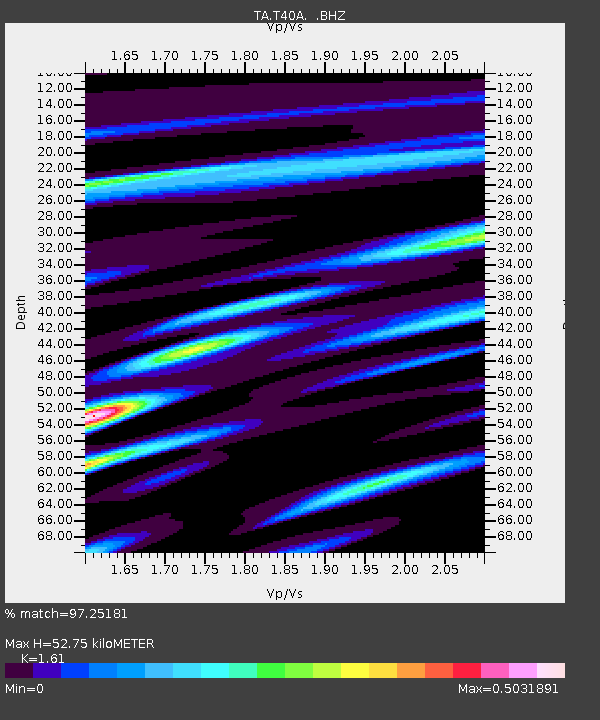
| Estimated Moho Depth: |
52.75 km |
| Estimated Crust Vp/Vs: |
1.61 |
| Assumed Crust Vp: |
6.53 km/s |
| Estimated Crust Vs: |
4.056 km/s |
| Estimated Crust Poisson's Ratio: |
0.19 |
|
| Radial Match: |
97.25181 % |
| Radial Bump: |
223 |
| Transverse Match: |
90.00857 % |
| Transverse Bump: |
400 |
| SOD ConfigId: |
446234 |
| Insert Time: |
2012-08-25 21:23:22.982 +0000 |
| GWidth: |
2.5 |
| Max Bumps: |
400 |
| Tol: |
0.001 |
|

Signal To Noise
| Channel | StoN | STA | LTA |
| TA:T40A: :BHZ:20120524T22:57:03.224988Z | 13.400076 | 1.328851E-6 | 9.916743E-8 |
| TA:T40A: :BHN:20120524T22:57:03.224988Z | 9.346997 | 5.8910035E-7 | 6.3025624E-8 |
| TA:T40A: :BHE:20120524T22:57:03.224988Z | 4.732068 | 1.9248301E-7 | 4.06763E-8 |
| Arrivals |
| Ps | 5.2 SECOND |
| PpPs | 20 SECOND |
| PsPs/PpSs | 25 SECOND |


