You are here: Home > Network List > G - GEOSCOPE Stations List
> Station RER Riviere de l'Est, La Reunion (Indian Ocean) > Earthquake Result Viewer
RER Riviere de l'Est, La Reunion (Indian Ocean) - Earthquake Result Viewer
| Earthquake location: |
Mindanao, Philippines |
| Earthquake latitude/longitude: |
6.9/126.6 |
| Earthquake time(UTC): |
2001/01/01 (001) 06:57:04 GMT |
| Earthquake Depth: |
33 km |
| Earthquake Magnitude: |
6.4 MB, 7.2 MS, 7.5 MW, 7.3 ME |
| Earthquake Catalog/Contributor: |
WHDF/NEIC |
|
| Network: |
G GEOSCOPE |
| Station: |
RER Riviere de l'Est, La Reunion (Indian Ocean) |
| Lat/Lon: |
21.16 S/55.75 E |
| Elevation: |
834 m |
|
| Distance: |
74.8 deg |
| Az: |
245.983 deg |
| Baz: |
76.316 deg |
| Ray Param: |
0.05201294 |
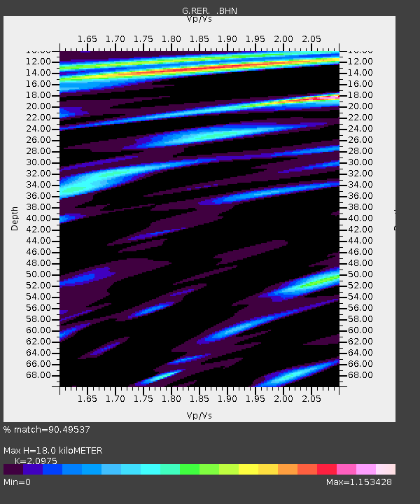
| Estimated Moho Depth: |
18.0 km |
| Estimated Crust Vp/Vs: |
2.10 |
| Assumed Crust Vp: |
4.73 km/s |
| Estimated Crust Vs: |
2.255 km/s |
| Estimated Crust Poisson's Ratio: |
0.35 |
|
| Radial Match: |
90.49537 % |
| Radial Bump: |
400 |
| Transverse Match: |
81.07878 % |
| Transverse Bump: |
400 |
| SOD ConfigId: |
3744 |
| Insert Time: |
2010-02-26 23:44:44.889 +0000 |
| GWidth: |
2.5 |
| Max Bumps: |
400 |
| Tol: |
0.001 |
|

Signal To Noise
| Channel | StoN | STA | LTA |
| G:RER: :BHN:20010101T07:08:10.349016Z | 0.9012647 | 8.401746E-7 | 9.3221735E-7 |
| G:RER: :BHE:20010101T07:08:10.349016Z | 2.3681428 | 1.7680117E-6 | 7.465815E-7 |
| G:RER: :BHZ:20010101T07:08:10.349016Z | 3.582358 | 3.1825416E-6 | 8.8839295E-7 |
| Arrivals |
| Ps | 4.2 SECOND |
| PpPs | 12 SECOND |
| PsPs/PpSs | 16 SECOND |


