You are here: Home > Network List > TA - USArray Transportable Network (new EarthScope stations) Stations List
> Station Z40A Long Farm, Magnolia, AR, USA > Earthquake Result Viewer
Z40A Long Farm, Magnolia, AR, USA - Earthquake Result Viewer
| Earthquake location: |
Norwegian Sea |
| Earthquake latitude/longitude: |
73.0/5.7 |
| Earthquake time(UTC): |
2012/05/24 (145) 22:47:46 GMT |
| Earthquake Depth: |
10 km |
| Earthquake Magnitude: |
5.7 MB, 6.1 MS, 6.1 MW, 6.2 MW |
| Earthquake Catalog/Contributor: |
WHDF/NEIC |
|
| Network: |
TA USArray Transportable Network (new EarthScope stations) |
| Station: |
Z40A Long Farm, Magnolia, AR, USA |
| Lat/Lon: |
33.26 N/93.40 W |
| Elevation: |
78 m |
|
| Distance: |
61.1 deg |
| Az: |
289.15 deg |
| Baz: |
19.415 deg |
| Ray Param: |
0.06106426 |
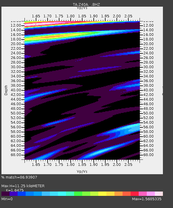
| Estimated Moho Depth: |
11.25 km |
| Estimated Crust Vp/Vs: |
1.65 |
| Assumed Crust Vp: |
6.245 km/s |
| Estimated Crust Vs: |
3.791 km/s |
| Estimated Crust Poisson's Ratio: |
0.21 |
|
| Radial Match: |
86.93907 % |
| Radial Bump: |
400 |
| Transverse Match: |
78.567665 % |
| Transverse Bump: |
398 |
| SOD ConfigId: |
446234 |
| Insert Time: |
2012-08-25 21:24:25.224 +0000 |
| GWidth: |
2.5 |
| Max Bumps: |
400 |
| Tol: |
0.001 |
|
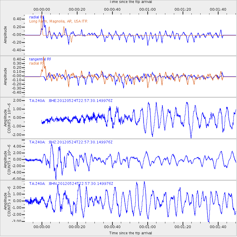
Signal To Noise
| Channel | StoN | STA | LTA |
| TA:Z40A: :BHZ:20120524T22:57:30.149976Z | 5.3908935 | 1.0529719E-6 | 1.9532419E-7 |
| TA:Z40A: :BHN:20120524T22:57:30.149976Z | 2.1679583 | 4.9430065E-7 | 2.2800282E-7 |
| TA:Z40A: :BHE:20120524T22:57:30.149976Z | 1.9524314 | 4.1291042E-7 | 2.1148523E-7 |
| Arrivals |
| Ps | 1.2 SECOND |
| PpPs | 4.6 SECOND |
| PsPs/PpSs | 5.8 SECOND |


