You are here: Home > Network List > TA - USArray Transportable Network (new EarthScope stations) Stations List
> Station 243A Waterproof, LA, USA > Earthquake Result Viewer
243A Waterproof, LA, USA - Earthquake Result Viewer
| Earthquake location: |
Norwegian Sea |
| Earthquake latitude/longitude: |
73.0/5.7 |
| Earthquake time(UTC): |
2012/05/24 (145) 22:47:46 GMT |
| Earthquake Depth: |
10 km |
| Earthquake Magnitude: |
5.7 MB, 6.1 MS, 6.1 MW, 6.2 MW |
| Earthquake Catalog/Contributor: |
WHDF/NEIC |
|
| Network: |
TA USArray Transportable Network (new EarthScope stations) |
| Station: |
243A Waterproof, LA, USA |
| Lat/Lon: |
31.88 N/91.48 W |
| Elevation: |
2.0 m |
|
| Distance: |
61.9 deg |
| Az: |
286.895 deg |
| Baz: |
19.367 deg |
| Ray Param: |
0.060577285 |
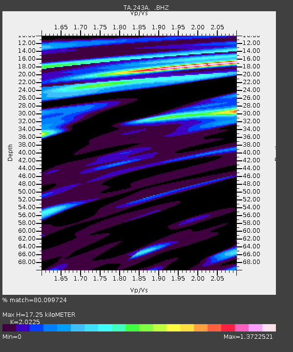
| Estimated Moho Depth: |
17.25 km |
| Estimated Crust Vp/Vs: |
2.02 |
| Assumed Crust Vp: |
6.065 km/s |
| Estimated Crust Vs: |
2.999 km/s |
| Estimated Crust Poisson's Ratio: |
0.34 |
|
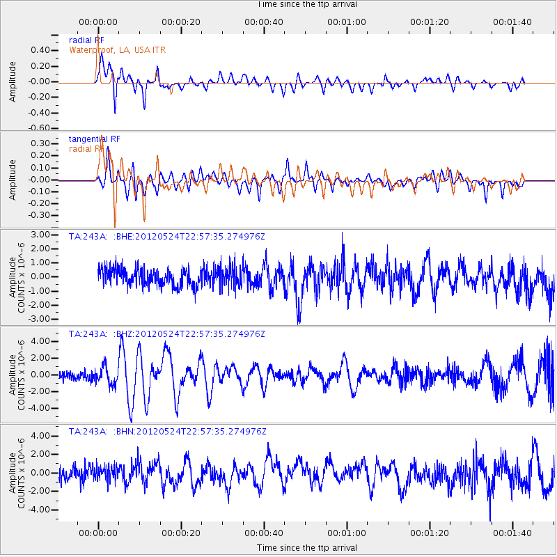
| Radial Match: |
80.099724 % |
| Radial Bump: |
400 |
| Transverse Match: |
79.53427 % |
| Transverse Bump: |
400 |
| SOD ConfigId: |
446234 |
| Insert Time: |
2012-08-25 21:24:52.028 +0000 |
| GWidth: |
2.5 |
| Max Bumps: |
400 |
| Tol: |
0.001 |
|
Signal To Noise
| Channel | StoN | STA | LTA |
| TA:243A: :BHZ:20120524T22:57:35.274976Z | 3.193209 | 1.0293804E-6 | 3.2236548E-7 |
| TA:243A: :BHN:20120524T22:57:35.274976Z | 1.1144044 | 7.1091864E-7 | 6.3793595E-7 |
| TA:243A: :BHE:20120524T22:57:35.274976Z | 1.2548976 | 7.2187146E-7 | 5.752433E-7 |
| Arrivals |
| Ps | 3.0 SECOND |
| PpPs | 8.3 SECOND |
| PsPs/PpSs | 11 SECOND |


