You are here: Home > Network List > TA - USArray Transportable Network (new EarthScope stations) Stations List
> Station Z41A Richland Creek Farm, El Dorado, AR, USA > Earthquake Result Viewer
Z41A Richland Creek Farm, El Dorado, AR, USA - Earthquake Result Viewer
| Earthquake location: |
Norwegian Sea |
| Earthquake latitude/longitude: |
73.0/5.7 |
| Earthquake time(UTC): |
2012/05/24 (145) 22:47:46 GMT |
| Earthquake Depth: |
10 km |
| Earthquake Magnitude: |
5.7 MB, 6.1 MS, 6.1 MW, 6.2 MW |
| Earthquake Catalog/Contributor: |
WHDF/NEIC |
|
| Network: |
TA USArray Transportable Network (new EarthScope stations) |
| Station: |
Z41A Richland Creek Farm, El Dorado, AR, USA |
| Lat/Lon: |
33.26 N/92.80 W |
| Elevation: |
62 m |
|
| Distance: |
61.0 deg |
| Az: |
288.612 deg |
| Baz: |
19.48 deg |
| Ray Param: |
0.06117386 |
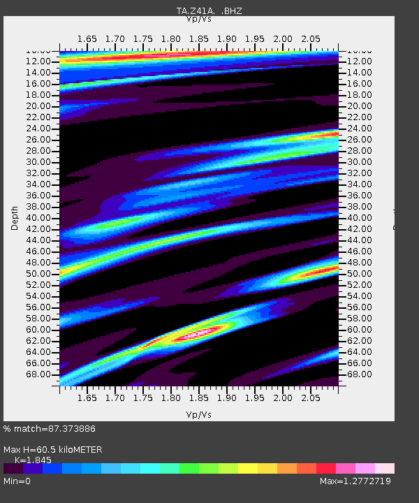
| Estimated Moho Depth: |
60.5 km |
| Estimated Crust Vp/Vs: |
1.85 |
| Assumed Crust Vp: |
6.245 km/s |
| Estimated Crust Vs: |
3.385 km/s |
| Estimated Crust Poisson's Ratio: |
0.29 |
|
| Radial Match: |
87.373886 % |
| Radial Bump: |
400 |
| Transverse Match: |
62.085922 % |
| Transverse Bump: |
400 |
| SOD ConfigId: |
446234 |
| Insert Time: |
2012-08-25 21:25:40.431 +0000 |
| GWidth: |
2.5 |
| Max Bumps: |
400 |
| Tol: |
0.001 |
|
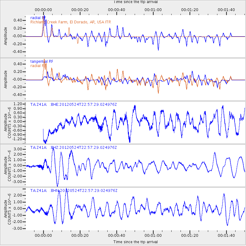
Signal To Noise
| Channel | StoN | STA | LTA |
| TA:Z41A: :BHZ:20120524T22:57:29.024976Z | 6.894463 | 8.152806E-7 | 1.1825149E-7 |
| TA:Z41A: :BHN:20120524T22:57:29.024976Z | 1.7002071 | 5.004428E-7 | 2.9434224E-7 |
| TA:Z41A: :BHE:20120524T22:57:29.024976Z | 0.63113636 | 3.0675523E-7 | 4.860364E-7 |
| Arrivals |
| Ps | 8.5 SECOND |
| PpPs | 26 SECOND |
| PsPs/PpSs | 35 SECOND |


