You are here: Home > Network List > TA - USArray Transportable Network (new EarthScope stations) Stations List
> Station T41A Mountain View, MO, USA > Earthquake Result Viewer
T41A Mountain View, MO, USA - Earthquake Result Viewer
| Earthquake location: |
Norwegian Sea |
| Earthquake latitude/longitude: |
73.0/5.7 |
| Earthquake time(UTC): |
2012/05/24 (145) 22:47:46 GMT |
| Earthquake Depth: |
10 km |
| Earthquake Magnitude: |
5.7 MB, 6.1 MS, 6.1 MW, 6.2 MW |
| Earthquake Catalog/Contributor: |
WHDF/NEIC |
|
| Network: |
TA USArray Transportable Network (new EarthScope stations) |
| Station: |
T41A Mountain View, MO, USA |
| Lat/Lon: |
37.04 N/91.76 W |
| Elevation: |
366 m |
|
| Distance: |
57.1 deg |
| Az: |
289.179 deg |
| Baz: |
20.368 deg |
| Ray Param: |
0.06368208 |
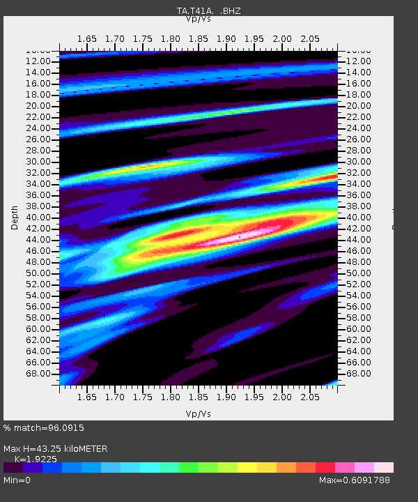
| Estimated Moho Depth: |
43.25 km |
| Estimated Crust Vp/Vs: |
1.92 |
| Assumed Crust Vp: |
6.53 km/s |
| Estimated Crust Vs: |
3.397 km/s |
| Estimated Crust Poisson's Ratio: |
0.31 |
|
| Radial Match: |
96.0915 % |
| Radial Bump: |
327 |
| Transverse Match: |
64.42662 % |
| Transverse Bump: |
400 |
| SOD ConfigId: |
446234 |
| Insert Time: |
2012-08-25 21:28:28.986 +0000 |
| GWidth: |
2.5 |
| Max Bumps: |
400 |
| Tol: |
0.001 |
|
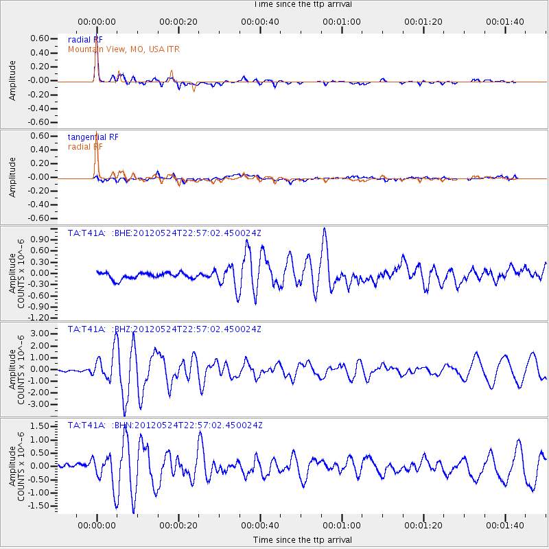
Signal To Noise
| Channel | StoN | STA | LTA |
| TA:T41A: :BHZ:20120524T22:57:02.450024Z | 20.593618 | 1.2872952E-6 | 6.250942E-8 |
| TA:T41A: :BHN:20120524T22:57:02.450024Z | 10.789466 | 6.103427E-7 | 5.6568386E-8 |
| TA:T41A: :BHE:20120524T22:57:02.450024Z | 3.6921291 | 3.0225462E-7 | 8.1864584E-8 |
| Arrivals |
| Ps | 6.4 SECOND |
| PpPs | 18 SECOND |
| PsPs/PpSs | 25 SECOND |


