You are here: Home > Network List > TA - USArray Transportable Network (new EarthScope stations) Stations List
> Station P41A Barry, Barry, IL, USA > Earthquake Result Viewer
P41A Barry, Barry, IL, USA - Earthquake Result Viewer

| Earthquake location: |
Norwegian Sea |
| Earthquake latitude/longitude: |
73.0/5.7 |
| Earthquake time(UTC): |
2012/05/24 (145) 22:47:46 GMT |
| Earthquake Depth: |
10 km |
| Earthquake Magnitude: |
5.7 MB, 6.1 MS, 6.1 MW, 6.2 MW |
| Earthquake Catalog/Contributor: |
WHDF/NEIC |
|
| Network: |
TA USArray Transportable Network (new EarthScope stations) |
| Station: |
P41A Barry, Barry, IL, USA |
| Lat/Lon: |
39.67 N/91.06 W |
| Elevation: |
215 m |
|
| Distance: |
54.5 deg |
| Az: |
289.679 deg |
| Baz: |
21.083 deg |
| Ray Param: |
0.06541772 |
| Estimated Moho Depth: |
31.0 km |
| Estimated Crust Vp/Vs: |
1.85 |
| Assumed Crust Vp: |
6.498 km/s |
| Estimated Crust Vs: |
3.512 km/s |
| Estimated Crust Poisson's Ratio: |
0.29 |
|
| Radial Match: |
96.21301 % |
| Radial Bump: |
295 |
| Transverse Match: |
68.21168 % |
| Transverse Bump: |
400 |
| SOD ConfigId: |
446234 |
| Insert Time: |
2012-08-25 21:29:30.889 +0000 |
| GWidth: |
2.5 |
| Max Bumps: |
400 |
| Tol: |
0.001 |
|
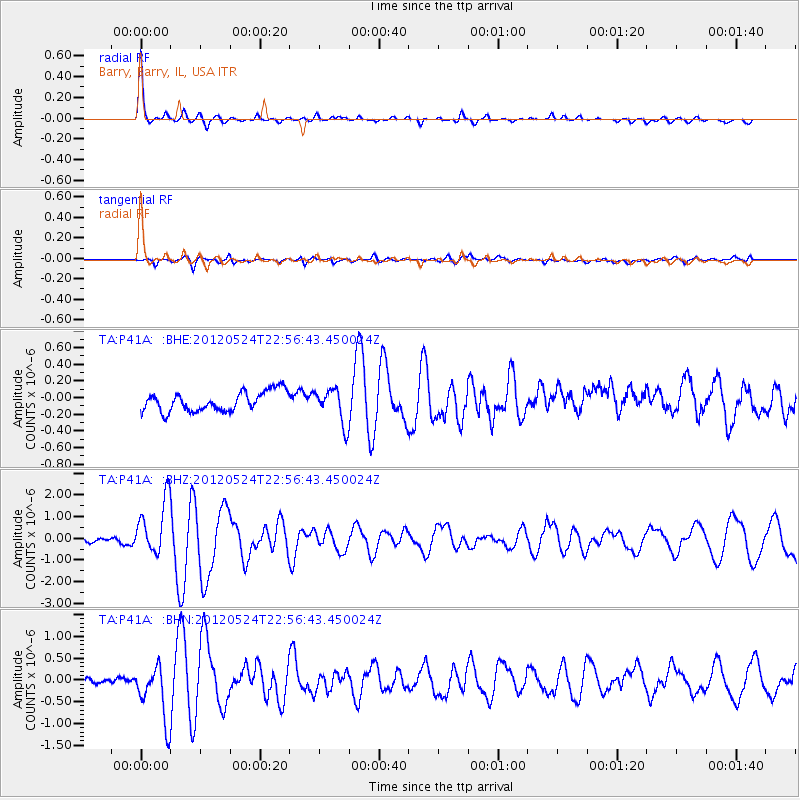
Signal To Noise
| Channel | StoN | STA | LTA |
| TA:P41A: :BHZ:20120524T22:56:43.450024Z | 16.361597 | 1.2794359E-6 | 7.8197495E-8 |
| TA:P41A: :BHN:20120524T22:56:43.450024Z | 8.031706 | 6.4235627E-7 | 7.997757E-8 |
| TA:P41A: :BHE:20120524T22:56:43.450024Z | 1.7527637 | 2.0744716E-7 | 1.18354315E-7 |
| Arrivals |
| Ps | 4.3 SECOND |
| PpPs | 13 SECOND |
| PsPs/PpSs | 17 SECOND |


