You are here: Home > Network List > TA - USArray Transportable Network (new EarthScope stations) Stations List
> Station S42A Caledonia, MO, USA > Earthquake Result Viewer
S42A Caledonia, MO, USA - Earthquake Result Viewer
| Earthquake location: |
Norwegian Sea |
| Earthquake latitude/longitude: |
73.0/5.7 |
| Earthquake time(UTC): |
2012/05/24 (145) 22:47:46 GMT |
| Earthquake Depth: |
10 km |
| Earthquake Magnitude: |
5.7 MB, 6.1 MS, 6.1 MW, 6.2 MW |
| Earthquake Catalog/Contributor: |
WHDF/NEIC |
|
| Network: |
TA USArray Transportable Network (new EarthScope stations) |
| Station: |
S42A Caledonia, MO, USA |
| Lat/Lon: |
37.77 N/90.79 W |
| Elevation: |
315 m |
|
| Distance: |
56.2 deg |
| Az: |
288.617 deg |
| Baz: |
20.646 deg |
| Ray Param: |
0.06430397 |
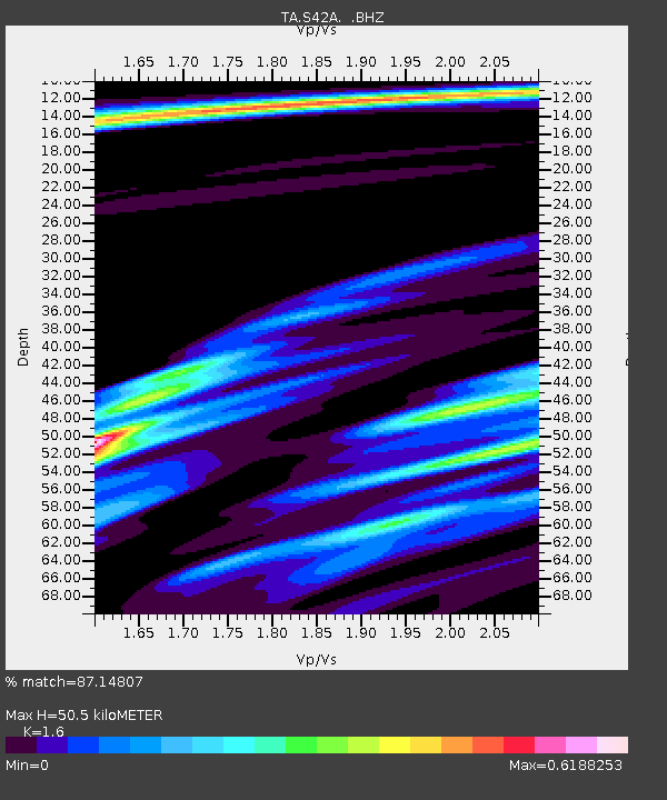
| Estimated Moho Depth: |
50.5 km |
| Estimated Crust Vp/Vs: |
1.60 |
| Assumed Crust Vp: |
6.53 km/s |
| Estimated Crust Vs: |
4.082 km/s |
| Estimated Crust Poisson's Ratio: |
0.18 |
|
| Radial Match: |
87.14807 % |
| Radial Bump: |
400 |
| Transverse Match: |
62.38744 % |
| Transverse Bump: |
400 |
| SOD ConfigId: |
446234 |
| Insert Time: |
2012-08-25 21:31:15.362 +0000 |
| GWidth: |
2.5 |
| Max Bumps: |
400 |
| Tol: |
0.001 |
|

Signal To Noise
| Channel | StoN | STA | LTA |
| TA:S42A: :BHZ:20120524T22:56:55.700024Z | 20.037336 | 1.0063521E-6 | 5.022385E-8 |
| TA:S42A: :BHN:20120524T22:56:55.700024Z | 4.4488997 | 5.092741E-7 | 1.1447192E-7 |
| TA:S42A: :BHE:20120524T22:56:55.700024Z | 2.0557144 | 2.1429271E-7 | 1.0424245E-7 |
| Arrivals |
| Ps | 4.9 SECOND |
| PpPs | 19 SECOND |
| PsPs/PpSs | 24 SECOND |


