You are here: Home > Network List > TA - USArray Transportable Network (new EarthScope stations) Stations List
> Station X42A Stuttgart, AR, USA > Earthquake Result Viewer
X42A Stuttgart, AR, USA - Earthquake Result Viewer
| Earthquake location: |
Norwegian Sea |
| Earthquake latitude/longitude: |
73.0/5.7 |
| Earthquake time(UTC): |
2012/05/24 (145) 22:47:46 GMT |
| Earthquake Depth: |
10 km |
| Earthquake Magnitude: |
5.7 MB, 6.1 MS, 6.1 MW, 6.2 MW |
| Earthquake Catalog/Contributor: |
WHDF/NEIC |
|
| Network: |
TA USArray Transportable Network (new EarthScope stations) |
| Station: |
X42A Stuttgart, AR, USA |
| Lat/Lon: |
34.55 N/91.63 W |
| Elevation: |
62 m |
|
| Distance: |
59.4 deg |
| Az: |
288.051 deg |
| Baz: |
19.855 deg |
| Ray Param: |
0.062190983 |
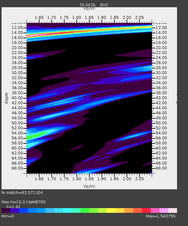
| Estimated Moho Depth: |
15.0 km |
| Estimated Crust Vp/Vs: |
1.61 |
| Assumed Crust Vp: |
6.273 km/s |
| Estimated Crust Vs: |
3.896 km/s |
| Estimated Crust Poisson's Ratio: |
0.19 |
|
| Radial Match: |
93.571304 % |
| Radial Bump: |
324 |
| Transverse Match: |
85.68513 % |
| Transverse Bump: |
400 |
| SOD ConfigId: |
446234 |
| Insert Time: |
2012-08-25 21:31:54.826 +0000 |
| GWidth: |
2.5 |
| Max Bumps: |
400 |
| Tol: |
0.001 |
|
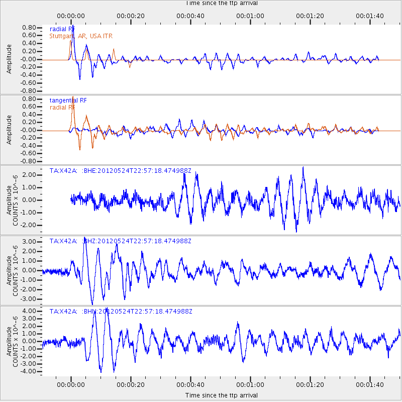
Signal To Noise
| Channel | StoN | STA | LTA |
| TA:X42A: :BHZ:20120524T22:57:18.474988Z | 7.8160753 | 1.2815633E-6 | 1.6396505E-7 |
| TA:X42A: :BHN:20120524T22:57:18.474988Z | 1.3352255 | 4.0118914E-7 | 3.0046547E-7 |
| TA:X42A: :BHE:20120524T22:57:18.474988Z | 1.2707222 | 4.33048E-7 | 3.4078892E-7 |
| Arrivals |
| Ps | 1.5 SECOND |
| PpPs | 5.9 SECOND |
| PsPs/PpSs | 7.5 SECOND |


