You are here: Home > Network List > TA - USArray Transportable Network (new EarthScope stations) Stations List
> Station M41A Milan, IL, USA > Earthquake Result Viewer
M41A Milan, IL, USA - Earthquake Result Viewer
| Earthquake location: |
Norwegian Sea |
| Earthquake latitude/longitude: |
73.0/5.7 |
| Earthquake time(UTC): |
2012/05/24 (145) 22:47:46 GMT |
| Earthquake Depth: |
10 km |
| Earthquake Magnitude: |
5.7 MB, 6.1 MS, 6.1 MW, 6.2 MW |
| Earthquake Catalog/Contributor: |
WHDF/NEIC |
|
| Network: |
TA USArray Transportable Network (new EarthScope stations) |
| Station: |
M41A Milan, IL, USA |
| Lat/Lon: |
41.38 N/90.54 W |
| Elevation: |
226 m |
|
| Distance: |
52.8 deg |
| Az: |
289.988 deg |
| Baz: |
21.603 deg |
| Ray Param: |
0.06655312 |
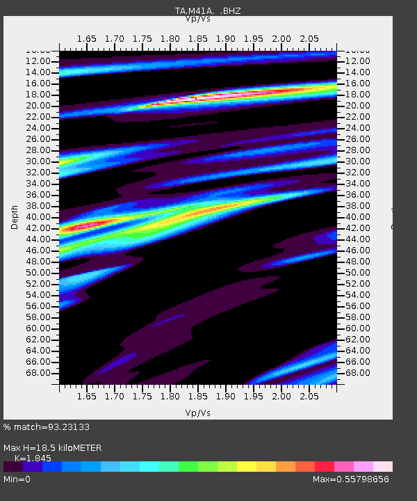
| Estimated Moho Depth: |
18.5 km |
| Estimated Crust Vp/Vs: |
1.85 |
| Assumed Crust Vp: |
6.498 km/s |
| Estimated Crust Vs: |
3.522 km/s |
| Estimated Crust Poisson's Ratio: |
0.29 |
|
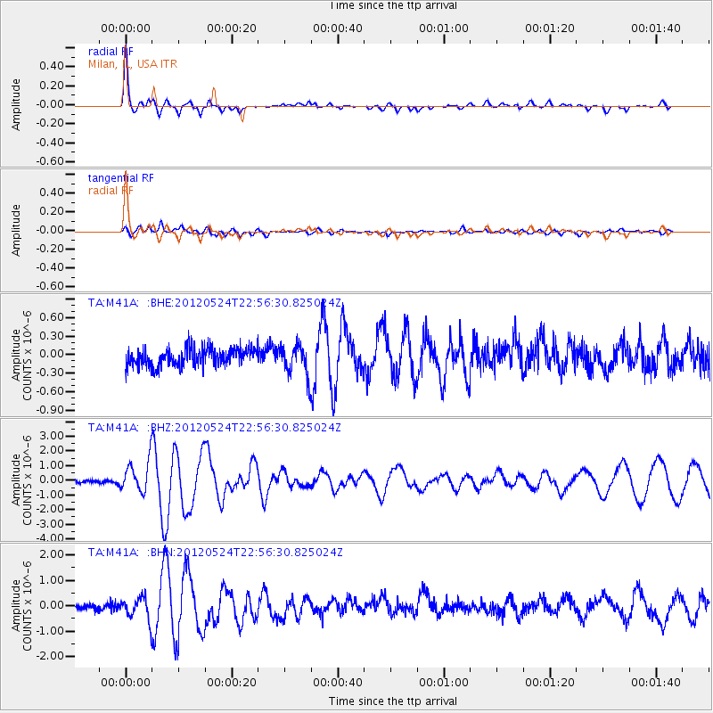
| Radial Match: |
93.23133 % |
| Radial Bump: |
400 |
| Transverse Match: |
74.55561 % |
| Transverse Bump: |
400 |
| SOD ConfigId: |
446234 |
| Insert Time: |
2012-08-25 21:32:18.128 +0000 |
| GWidth: |
2.5 |
| Max Bumps: |
400 |
| Tol: |
0.001 |
|
Signal To Noise
| Channel | StoN | STA | LTA |
| TA:M41A: :BHZ:20120524T22:56:30.825024Z | 8.290359 | 1.0923593E-6 | 1.3176262E-7 |
| TA:M41A: :BHN:20120524T22:56:30.825024Z | 3.5454109 | 4.424504E-7 | 1.2479525E-7 |
| TA:M41A: :BHE:20120524T22:56:30.825024Z | 1.8059243 | 2.58075E-7 | 1.4290465E-7 |
| Arrivals |
| Ps | 2.5 SECOND |
| PpPs | 7.7 SECOND |
| PsPs/PpSs | 10 SECOND |


