You are here: Home > Network List > CI - Caltech Regional Seismic Network Stations List
> Station LGU LGU, Camarillo, CA, USA > Earthquake Result Viewer
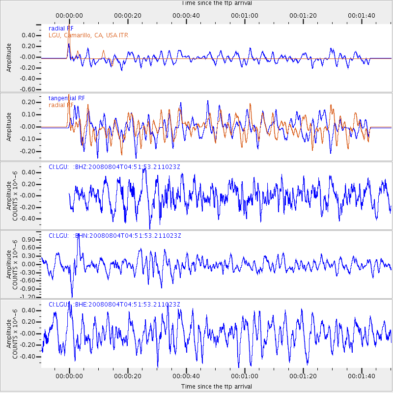
LGU LGU, Camarillo, CA, USA - Earthquake Result Viewer
*The percent match for this event was below the threshold and hence no stack was calculated.
| Earthquake location: |
Kuril Islands |
| Earthquake latitude/longitude: |
49.9/156.4 |
| Earthquake time(UTC): |
2008/08/04 (217) 04:42:14 GMT |
| Earthquake Depth: |
77 km |
| Earthquake Magnitude: |
5.6 MB, 5.8 MW, 5.7 MW |
| Earthquake Catalog/Contributor: |
WHDF/NEIC |
|
| Network: |
CI Caltech Regional Seismic Network |
| Station: |
LGU LGU, Camarillo, CA, USA |
| Lat/Lon: |
34.11 N/119.07 W |
| Elevation: |
416 m |
|
| Distance: |
61.5 deg |
| Az: |
69.96 deg |
| Baz: |
312.87 deg |
| Ray Param: |
$rayparam |
*The percent match for this event was below the threshold and hence was not used in the summary stack. |
|
| Radial Match: |
62.88766 % |
| Radial Bump: |
400 |
| Transverse Match: |
56.39708 % |
| Transverse Bump: |
400 |
| SOD ConfigId: |
2504 |
| Insert Time: |
2010-02-25 20:22:04.861 +0000 |
| GWidth: |
2.5 |
| Max Bumps: |
400 |
| Tol: |
0.001 |
|
Signal To Noise
| Channel | StoN | STA | LTA |
| CI:LGU: :BHN:20080804T04:51:53.211023Z | 3.3160906 | 5.4764354E-7 | 1.6514734E-7 |
| CI:LGU: :BHE:20080804T04:51:53.211023Z | 1.5913404 | 2.9745877E-7 | 1.869234E-7 |
| CI:LGU: :BHZ:20080804T04:51:53.211023Z | 1.1010574 | 1.9875246E-7 | 1.8051053E-7 |
| Arrivals |
| Ps | |
| PpPs | |
| PsPs/PpSs | |


