You are here: Home > Network List > TA - USArray Transportable Network (new EarthScope stations) Stations List
> Station H39A Augusta, WI, USA > Earthquake Result Viewer
H39A Augusta, WI, USA - Earthquake Result Viewer
| Earthquake location: |
Norwegian Sea |
| Earthquake latitude/longitude: |
73.0/5.7 |
| Earthquake time(UTC): |
2012/05/24 (145) 22:47:46 GMT |
| Earthquake Depth: |
10 km |
| Earthquake Magnitude: |
5.7 MB, 6.1 MS, 6.1 MW, 6.2 MW |
| Earthquake Catalog/Contributor: |
WHDF/NEIC |
|
| Network: |
TA USArray Transportable Network (new EarthScope stations) |
| Station: |
H39A Augusta, WI, USA |
| Lat/Lon: |
44.68 N/91.28 W |
| Elevation: |
345 m |
|
| Distance: |
49.9 deg |
| Az: |
292.221 deg |
| Baz: |
22.495 deg |
| Ray Param: |
0.068404995 |
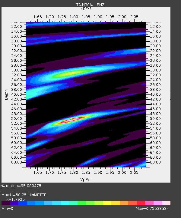
| Estimated Moho Depth: |
50.25 km |
| Estimated Crust Vp/Vs: |
1.79 |
| Assumed Crust Vp: |
6.571 km/s |
| Estimated Crust Vs: |
3.666 km/s |
| Estimated Crust Poisson's Ratio: |
0.27 |
|
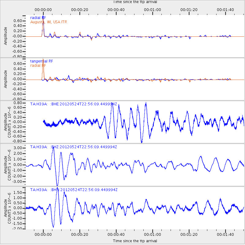
| Radial Match: |
95.080475 % |
| Radial Bump: |
229 |
| Transverse Match: |
87.58799 % |
| Transverse Bump: |
362 |
| SOD ConfigId: |
446234 |
| Insert Time: |
2012-08-25 21:32:52.914 +0000 |
| GWidth: |
2.5 |
| Max Bumps: |
400 |
| Tol: |
0.001 |
|
Signal To Noise
| Channel | StoN | STA | LTA |
| TA:H39A: :BHZ:20120524T22:56:09.449994Z | 7.86562 | 6.8838733E-7 | 8.75185E-8 |
| TA:H39A: :BHN:20120524T22:56:09.449994Z | 5.0408325 | 3.878344E-7 | 7.693856E-8 |
| TA:H39A: :BHE:20120524T22:56:09.449994Z | 2.0290039 | 1.6667025E-7 | 8.214388E-8 |
| Arrivals |
| Ps | 6.4 SECOND |
| PpPs | 20 SECOND |
| PsPs/PpSs | 27 SECOND |


