You are here: Home > Network List > TA - USArray Transportable Network (new EarthScope stations) Stations List
> Station G41A Antigo, WI, USA > Earthquake Result Viewer
G41A Antigo, WI, USA - Earthquake Result Viewer
| Earthquake location: |
Norwegian Sea |
| Earthquake latitude/longitude: |
73.0/5.7 |
| Earthquake time(UTC): |
2012/05/24 (145) 22:47:46 GMT |
| Earthquake Depth: |
10 km |
| Earthquake Magnitude: |
5.7 MB, 6.1 MS, 6.1 MW, 6.2 MW |
| Earthquake Catalog/Contributor: |
WHDF/NEIC |
|
| Network: |
TA USArray Transportable Network (new EarthScope stations) |
| Station: |
G41A Antigo, WI, USA |
| Lat/Lon: |
45.21 N/89.18 W |
| Elevation: |
464 m |
|
| Distance: |
48.8 deg |
| Az: |
290.678 deg |
| Baz: |
22.97 deg |
| Ray Param: |
0.069096625 |
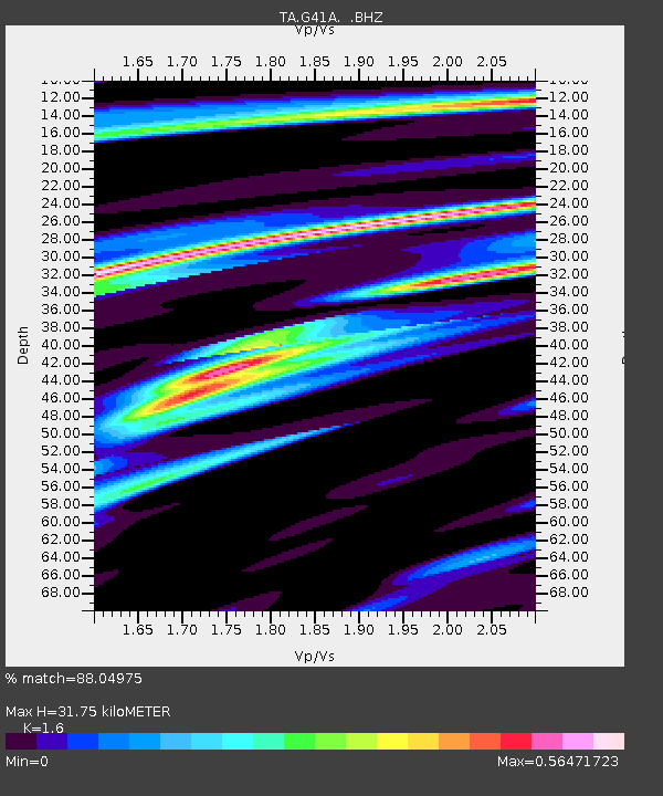
| Estimated Moho Depth: |
31.75 km |
| Estimated Crust Vp/Vs: |
1.60 |
| Assumed Crust Vp: |
6.41 km/s |
| Estimated Crust Vs: |
4.006 km/s |
| Estimated Crust Poisson's Ratio: |
0.18 |
|
| Radial Match: |
88.04975 % |
| Radial Bump: |
331 |
| Transverse Match: |
81.00099 % |
| Transverse Bump: |
400 |
| SOD ConfigId: |
446234 |
| Insert Time: |
2012-08-25 21:33:36.249 +0000 |
| GWidth: |
2.5 |
| Max Bumps: |
400 |
| Tol: |
0.001 |
|
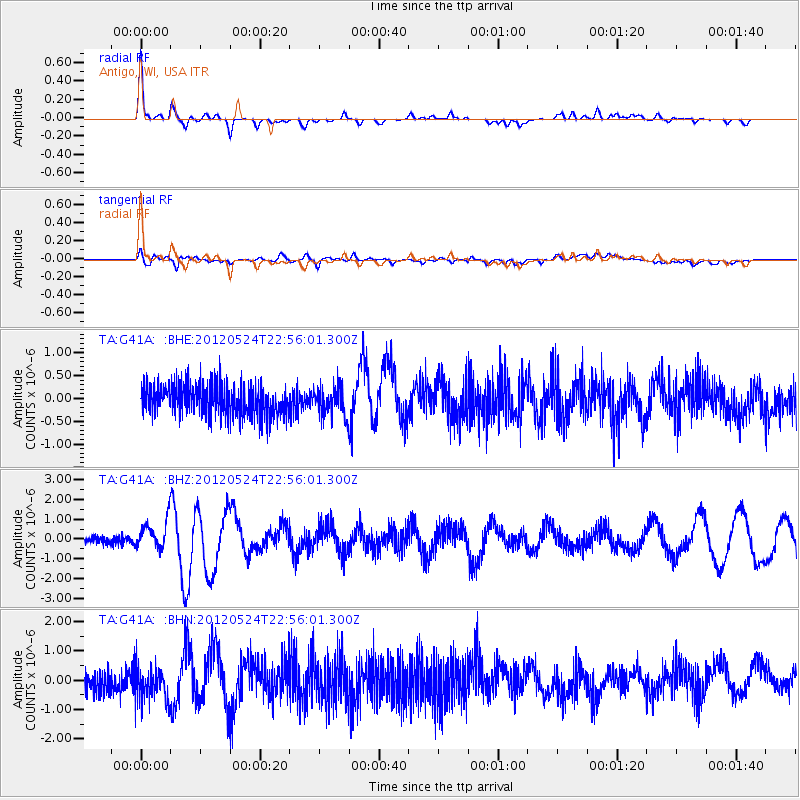
Signal To Noise
| Channel | StoN | STA | LTA |
| TA:G41A: :BHZ:20120524T22:56:01.300Z | 3.01118 | 7.369246E-7 | 2.447295E-7 |
| TA:G41A: :BHN:20120524T22:56:01.300Z | 1.4276211 | 5.744037E-7 | 4.0235028E-7 |
| TA:G41A: :BHE:20120524T22:56:01.300Z | 0.9503551 | 3.1993227E-7 | 3.3664497E-7 |
| Arrivals |
| Ps | 3.2 SECOND |
| PpPs | 12 SECOND |
| PsPs/PpSs | 15 SECOND |


