You are here: Home > Network List > TA - USArray Transportable Network (new EarthScope stations) Stations List
> Station M40A Post Highland Seismo, Ainsworth, IA, USA > Earthquake Result Viewer
M40A Post Highland Seismo, Ainsworth, IA, USA - Earthquake Result Viewer
| Earthquake location: |
Norwegian Sea |
| Earthquake latitude/longitude: |
73.0/5.7 |
| Earthquake time(UTC): |
2012/05/24 (145) 22:47:46 GMT |
| Earthquake Depth: |
10 km |
| Earthquake Magnitude: |
5.7 MB, 6.1 MS, 6.1 MW, 6.2 MW |
| Earthquake Catalog/Contributor: |
WHDF/NEIC |
|
| Network: |
TA USArray Transportable Network (new EarthScope stations) |
| Station: |
M40A Post Highland Seismo, Ainsworth, IA, USA |
| Lat/Lon: |
41.41 N/91.51 W |
| Elevation: |
223 m |
|
| Distance: |
53.0 deg |
| Az: |
290.854 deg |
| Baz: |
21.486 deg |
| Ray Param: |
0.066393904 |
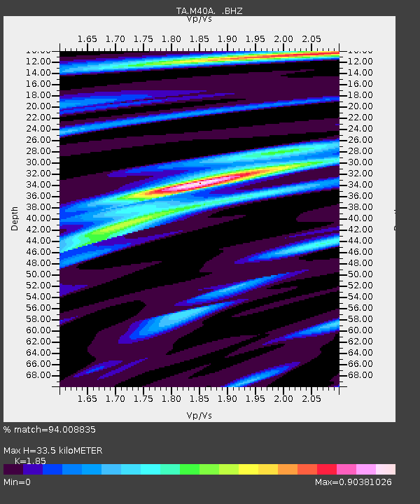
| Estimated Moho Depth: |
33.5 km |
| Estimated Crust Vp/Vs: |
1.85 |
| Assumed Crust Vp: |
6.498 km/s |
| Estimated Crust Vs: |
3.512 km/s |
| Estimated Crust Poisson's Ratio: |
0.29 |
|
| Radial Match: |
94.008835 % |
| Radial Bump: |
352 |
| Transverse Match: |
78.48776 % |
| Transverse Bump: |
400 |
| SOD ConfigId: |
446234 |
| Insert Time: |
2012-08-25 21:34:04.100 +0000 |
| GWidth: |
2.5 |
| Max Bumps: |
400 |
| Tol: |
0.001 |
|

Signal To Noise
| Channel | StoN | STA | LTA |
| TA:M40A: :BHZ:20120524T22:56:32.599988Z | 11.056093 | 1.0471846E-6 | 9.471561E-8 |
| TA:M40A: :BHN:20120524T22:56:32.599988Z | 4.438323 | 6.230819E-7 | 1.4038679E-7 |
| TA:M40A: :BHE:20120524T22:56:32.599988Z | 1.5001063 | 2.820222E-7 | 1.8800148E-7 |
| Arrivals |
| Ps | 4.6 SECOND |
| PpPs | 14 SECOND |
| PsPs/PpSs | 19 SECOND |


