You are here: Home > Network List > TA - USArray Transportable Network (new EarthScope stations) Stations List
> Station F41A Wisconsin Rapids, WI, USA > Earthquake Result Viewer
F41A Wisconsin Rapids, WI, USA - Earthquake Result Viewer
| Earthquake location: |
Norwegian Sea |
| Earthquake latitude/longitude: |
73.0/5.7 |
| Earthquake time(UTC): |
2012/05/24 (145) 22:47:46 GMT |
| Earthquake Depth: |
10 km |
| Earthquake Magnitude: |
5.7 MB, 6.1 MS, 6.1 MW, 6.2 MW |
| Earthquake Catalog/Contributor: |
WHDF/NEIC |
|
| Network: |
TA USArray Transportable Network (new EarthScope stations) |
| Station: |
F41A Wisconsin Rapids, WI, USA |
| Lat/Lon: |
45.74 N/89.10 W |
| Elevation: |
509 m |
|
| Distance: |
48.3 deg |
| Az: |
290.887 deg |
| Baz: |
23.162 deg |
| Ray Param: |
0.06943139 |
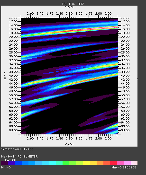
| Estimated Moho Depth: |
14.75 km |
| Estimated Crust Vp/Vs: |
2.08 |
| Assumed Crust Vp: |
6.41 km/s |
| Estimated Crust Vs: |
3.082 km/s |
| Estimated Crust Poisson's Ratio: |
0.35 |
|
| Radial Match: |
93.317406 % |
| Radial Bump: |
400 |
| Transverse Match: |
56.59957 % |
| Transverse Bump: |
400 |
| SOD ConfigId: |
446234 |
| Insert Time: |
2012-08-25 21:34:15.786 +0000 |
| GWidth: |
2.5 |
| Max Bumps: |
400 |
| Tol: |
0.001 |
|
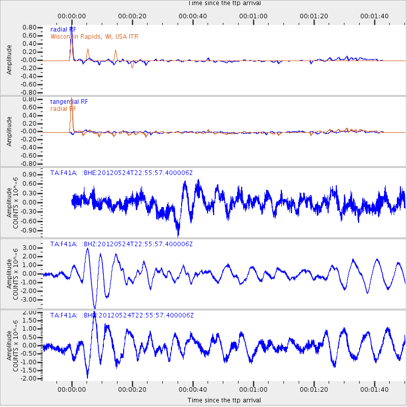
Signal To Noise
| Channel | StoN | STA | LTA |
| TA:F41A: :BHZ:20120524T22:55:57.400006Z | 8.22523 | 8.9137654E-7 | 1.0837102E-7 |
| TA:F41A: :BHN:20120524T22:55:57.400006Z | 3.373228 | 5.4040135E-7 | 1.6020302E-7 |
| TA:F41A: :BHE:20120524T22:55:57.400006Z | 2.7751384 | 4.268816E-7 | 1.5382354E-7 |
| Arrivals |
| Ps | 2.6 SECOND |
| PpPs | 6.7 SECOND |
| PsPs/PpSs | 9.4 SECOND |


