You are here: Home > Network List > G - GEOSCOPE Stations List
> Station RER Riviere de l'Est, La Reunion (Indian Ocean) > Earthquake Result Viewer
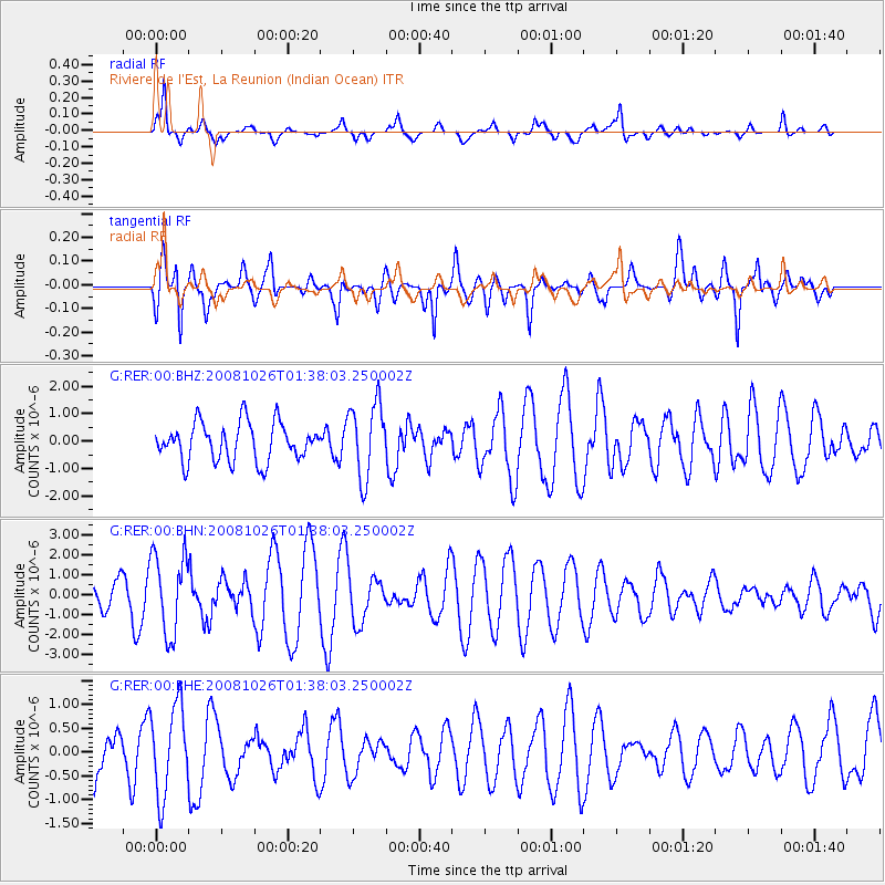
RER Riviere de l'Est, La Reunion (Indian Ocean) - Earthquake Result Viewer
*The percent match for this event was below the threshold and hence no stack was calculated.
| Earthquake location: |
Hindu Kush Region, Afghanistan |
| Earthquake latitude/longitude: |
36.5/70.7 |
| Earthquake time(UTC): |
2008/10/26 (300) 01:28:56 GMT |
| Earthquake Depth: |
210 km |
| Earthquake Magnitude: |
5.5 MB, 5.7 MW, 5.7 MW |
| Earthquake Catalog/Contributor: |
WHDF/NEIC |
|
| Network: |
G GEOSCOPE |
| Station: |
RER Riviere de l'Est, La Reunion (Indian Ocean) |
| Lat/Lon: |
21.16 S/55.75 E |
| Elevation: |
834 m |
|
| Distance: |
59.0 deg |
| Az: |
196.292 deg |
| Baz: |
14.017 deg |
| Ray Param: |
$rayparam |
*The percent match for this event was below the threshold and hence was not used in the summary stack. |
|
| Radial Match: |
63.643013 % |
| Radial Bump: |
400 |
| Transverse Match: |
62.690166 % |
| Transverse Bump: |
400 |
| SOD ConfigId: |
2560 |
| Insert Time: |
2010-02-26 23:45:10.235 +0000 |
| GWidth: |
2.5 |
| Max Bumps: |
400 |
| Tol: |
0.001 |
|
Signal To Noise
| Channel | StoN | STA | LTA |
| G:RER:00:BHN:20081026T01:38:03.250002Z | 1.6753289 | 2.0050943E-6 | 1.1968363E-6 |
| G:RER:00:BHE:20081026T01:38:03.250002Z | 1.1922628 | 9.391446E-7 | 7.876993E-7 |
| G:RER:00:BHZ:20081026T01:38:03.250002Z | 1.9729344 | 1.3708867E-6 | 6.9484656E-7 |
| Arrivals |
| Ps | |
| PpPs | |
| PsPs/PpSs | |


