You are here: Home > Network List > TA - USArray Transportable Network (new EarthScope stations) Stations List
> Station J04D Umpqua National Forest, Toketee, OR, USA > Earthquake Result Viewer
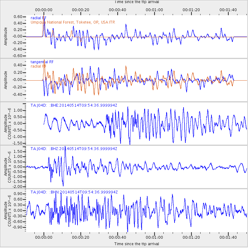
J04D Umpqua National Forest, Toketee, OR, USA - Earthquake Result Viewer
*The percent match for this event was below the threshold and hence no stack was calculated.
| Earthquake location: |
South Of Panama |
| Earthquake latitude/longitude: |
7.3/-82.4 |
| Earthquake time(UTC): |
2014/05/14 (134) 09:46:14 GMT |
| Earthquake Depth: |
9.3 km |
| Earthquake Magnitude: |
5.3 MW |
| Earthquake Catalog/Contributor: |
ISC/ISC |
|
| Network: |
TA USArray Transportable Network (new EarthScope stations) |
| Station: |
J04D Umpqua National Forest, Toketee, OR, USA |
| Lat/Lon: |
43.24 N/122.11 W |
| Elevation: |
1948 m |
|
| Distance: |
49.9 deg |
| Az: |
322.361 deg |
| Baz: |
124.012 deg |
| Ray Param: |
$rayparam |
*The percent match for this event was below the threshold and hence was not used in the summary stack. |
|
| Radial Match: |
64.65501 % |
| Radial Bump: |
400 |
| Transverse Match: |
74.76289 % |
| Transverse Bump: |
400 |
| SOD ConfigId: |
3390531 |
| Insert Time: |
2019-04-11 21:25:22.804 +0000 |
| GWidth: |
2.5 |
| Max Bumps: |
400 |
| Tol: |
0.001 |
|
Signal To Noise
| Channel | StoN | STA | LTA |
| TA:J04D: :BHZ:20140514T09:54:36.999994Z | 4.9958906 | 4.583037E-7 | 9.173613E-8 |
| TA:J04D: :BHN:20140514T09:54:36.999994Z | 1.3647109 | 2.923423E-7 | 2.1421553E-7 |
| TA:J04D: :BHE:20140514T09:54:36.999994Z | 0.99508274 | 3.040425E-7 | 3.0554492E-7 |
| Arrivals |
| Ps | |
| PpPs | |
| PsPs/PpSs | |


