You are here: Home > Network List > G - GEOSCOPE Stations List
> Station RER Riviere de l'Est, La Reunion (Indian Ocean) > Earthquake Result Viewer
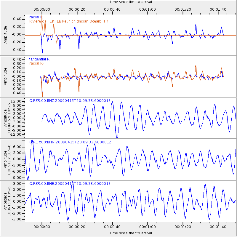
RER Riviere de l'Est, La Reunion (Indian Ocean) - Earthquake Result Viewer
*The percent match for this event was below the threshold and hence no stack was calculated.
| Earthquake location: |
Southern Sumatra, Indonesia |
| Earthquake latitude/longitude: |
-3.1/100.5 |
| Earthquake time(UTC): |
2009/04/15 (105) 20:01:34 GMT |
| Earthquake Depth: |
20 km |
| Earthquake Magnitude: |
6.1 MB, 6.4 MS, 6.4 MW, 6.2 MW |
| Earthquake Catalog/Contributor: |
WHDF/NEIC |
|
| Network: |
G GEOSCOPE |
| Station: |
RER Riviere de l'Est, La Reunion (Indian Ocean) |
| Lat/Lon: |
21.16 S/55.75 E |
| Elevation: |
834 m |
|
| Distance: |
47.0 deg |
| Az: |
243.848 deg |
| Baz: |
73.797 deg |
| Ray Param: |
$rayparam |
*The percent match for this event was below the threshold and hence was not used in the summary stack. |
|
| Radial Match: |
60.799942 % |
| Radial Bump: |
323 |
| Transverse Match: |
59.800903 % |
| Transverse Bump: |
354 |
| SOD ConfigId: |
2658 |
| Insert Time: |
2010-02-26 23:45:18.194 +0000 |
| GWidth: |
2.5 |
| Max Bumps: |
400 |
| Tol: |
0.001 |
|
Signal To Noise
| Channel | StoN | STA | LTA |
| G:RER:00:BHN:20090415T20:09:33.600001Z | 0.88223684 | 4.203446E-6 | 4.7645326E-6 |
| G:RER:00:BHE:20090415T20:09:33.600001Z | 0.36736798 | 8.248602E-7 | 2.2453241E-6 |
| G:RER:00:BHZ:20090415T20:09:33.600001Z | 2.1804838 | 6.089436E-6 | 2.7926997E-6 |
| Arrivals |
| Ps | |
| PpPs | |
| PsPs/PpSs | |


