You are here: Home > Network List > TA - USArray Transportable Network (new EarthScope stations) Stations List
> Station T45A Paducah, KY, USA > Earthquake Result Viewer
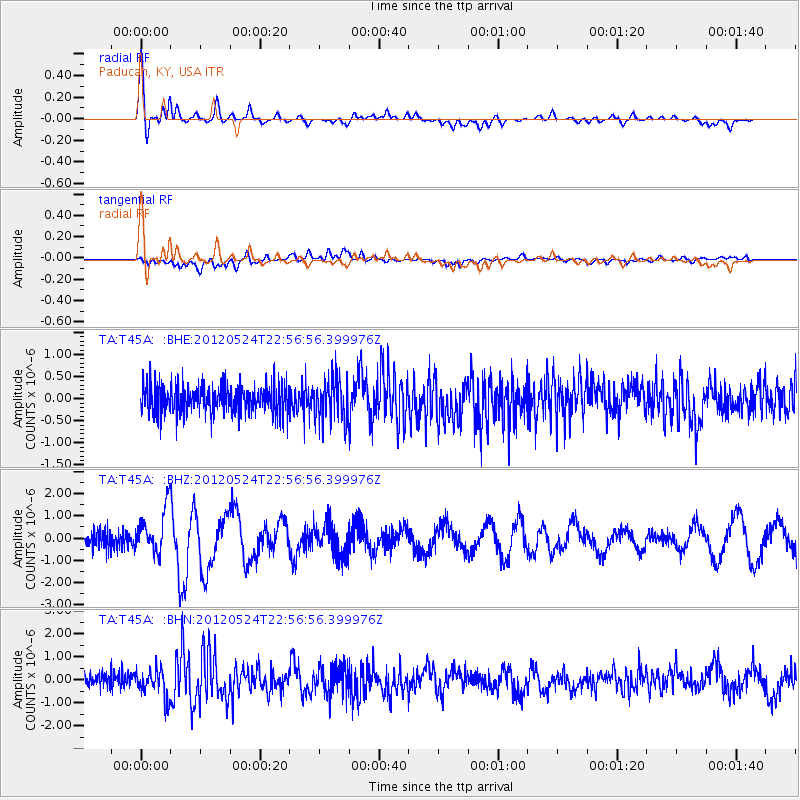
T45A Paducah, KY, USA - Earthquake Result Viewer

| Earthquake location: |
Norwegian Sea |
| Earthquake latitude/longitude: |
73.0/5.7 |
| Earthquake time(UTC): |
2012/05/24 (145) 22:47:46 GMT |
| Earthquake Depth: |
10 km |
| Earthquake Magnitude: |
5.7 MB, 6.1 MS, 6.1 MW, 6.2 MW |
| Earthquake Catalog/Contributor: |
WHDF/NEIC |
|
| Network: |
TA USArray Transportable Network (new EarthScope stations) |
| Station: |
T45A Paducah, KY, USA |
| Lat/Lon: |
37.02 N/88.64 W |
| Elevation: |
119 m |
|
| Distance: |
56.3 deg |
| Az: |
286.372 deg |
| Baz: |
20.698 deg |
| Ray Param: |
0.064241126 |
| Estimated Moho Depth: |
32.0 km |
| Estimated Crust Vp/Vs: |
1.70 |
| Assumed Crust Vp: |
6.444 km/s |
| Estimated Crust Vs: |
3.785 km/s |
| Estimated Crust Poisson's Ratio: |
0.24 |
|
| Radial Match: |
88.62302 % |
| Radial Bump: |
400 |
| Transverse Match: |
62.555634 % |
| Transverse Bump: |
400 |
| SOD ConfigId: |
446234 |
| Insert Time: |
2012-08-25 21:37:29.518 +0000 |
| GWidth: |
2.5 |
| Max Bumps: |
400 |
| Tol: |
0.001 |
|
Signal To Noise
| Channel | StoN | STA | LTA |
| TA:T45A: :BHZ:20120524T22:56:56.399976Z | 3.3588204 | 1.0145436E-6 | 3.0205354E-7 |
| TA:T45A: :BHN:20120524T22:56:56.399976Z | 2.2318637 | 6.0585415E-7 | 2.714566E-7 |
| TA:T45A: :BHE:20120524T22:56:56.399976Z | 1.4781923 | 4.7196536E-7 | 3.192855E-7 |
| Arrivals |
| Ps | 3.7 SECOND |
| PpPs | 13 SECOND |
| PsPs/PpSs | 16 SECOND |


