You are here: Home > Network List > TA - USArray Transportable Network (new EarthScope stations) Stations List
> Station T46A Princeton, KY, USA > Earthquake Result Viewer
T46A Princeton, KY, USA - Earthquake Result Viewer
| Earthquake location: |
Norwegian Sea |
| Earthquake latitude/longitude: |
73.0/5.7 |
| Earthquake time(UTC): |
2012/05/24 (145) 22:47:46 GMT |
| Earthquake Depth: |
10 km |
| Earthquake Magnitude: |
5.7 MB, 6.1 MS, 6.1 MW, 6.2 MW |
| Earthquake Catalog/Contributor: |
WHDF/NEIC |
|
| Network: |
TA USArray Transportable Network (new EarthScope stations) |
| Station: |
T46A Princeton, KY, USA |
| Lat/Lon: |
37.04 N/87.89 W |
| Elevation: |
169 m |
|
| Distance: |
56.1 deg |
| Az: |
285.706 deg |
| Baz: |
20.777 deg |
| Ray Param: |
0.064393066 |
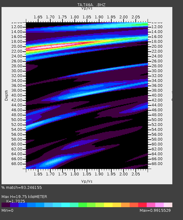
| Estimated Moho Depth: |
19.75 km |
| Estimated Crust Vp/Vs: |
1.70 |
| Assumed Crust Vp: |
6.444 km/s |
| Estimated Crust Vs: |
3.785 km/s |
| Estimated Crust Poisson's Ratio: |
0.24 |
|
| Radial Match: |
93.246155 % |
| Radial Bump: |
400 |
| Transverse Match: |
59.738777 % |
| Transverse Bump: |
400 |
| SOD ConfigId: |
446234 |
| Insert Time: |
2012-08-25 21:37:41.866 +0000 |
| GWidth: |
2.5 |
| Max Bumps: |
400 |
| Tol: |
0.001 |
|
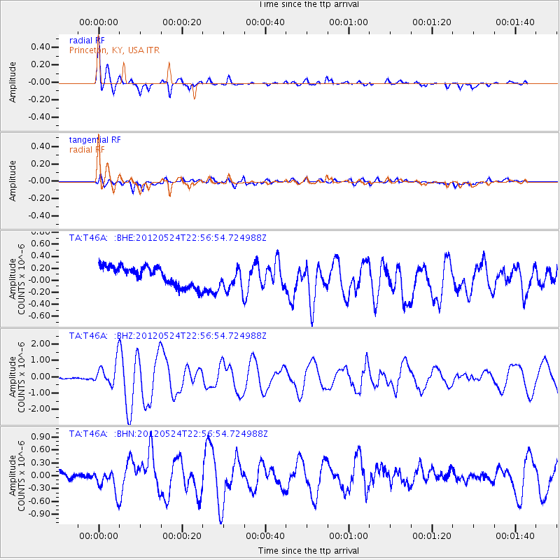
Signal To Noise
| Channel | StoN | STA | LTA |
| TA:T46A: :BHZ:20120524T22:56:54.724988Z | 6.4125967 | 8.1081566E-7 | 1.2644108E-7 |
| TA:T46A: :BHN:20120524T22:56:54.724988Z | 3.4039474 | 2.7743948E-7 | 8.150522E-8 |
| TA:T46A: :BHE:20120524T22:56:54.724988Z | 1.2540247 | 1.9984623E-7 | 1.5936386E-7 |
| Arrivals |
| Ps | 2.3 SECOND |
| PpPs | 7.8 SECOND |
| PsPs/PpSs | 10 SECOND |


