You are here: Home > Network List > TA - USArray Transportable Network (new EarthScope stations) Stations List
> Station T48A Bowling Green, KY, USA > Earthquake Result Viewer
T48A Bowling Green, KY, USA - Earthquake Result Viewer
| Earthquake location: |
Norwegian Sea |
| Earthquake latitude/longitude: |
73.0/5.7 |
| Earthquake time(UTC): |
2012/05/24 (145) 22:47:46 GMT |
| Earthquake Depth: |
10 km |
| Earthquake Magnitude: |
5.7 MB, 6.1 MS, 6.1 MW, 6.2 MW |
| Earthquake Catalog/Contributor: |
WHDF/NEIC |
|
| Network: |
TA USArray Transportable Network (new EarthScope stations) |
| Station: |
T48A Bowling Green, KY, USA |
| Lat/Lon: |
37.11 N/86.39 W |
| Elevation: |
218 m |
|
| Distance: |
55.6 deg |
| Az: |
284.38 deg |
| Baz: |
20.932 deg |
| Ray Param: |
0.06471229 |
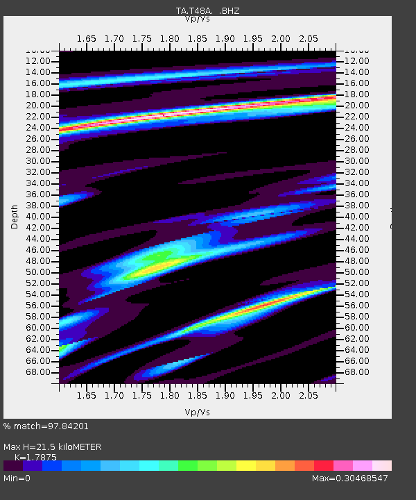
| Estimated Moho Depth: |
21.5 km |
| Estimated Crust Vp/Vs: |
1.79 |
| Assumed Crust Vp: |
6.444 km/s |
| Estimated Crust Vs: |
3.605 km/s |
| Estimated Crust Poisson's Ratio: |
0.27 |
|
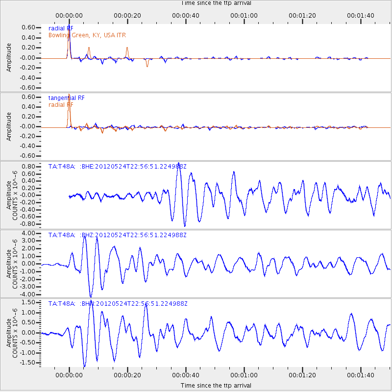
| Radial Match: |
97.84201 % |
| Radial Bump: |
169 |
| Transverse Match: |
86.74224 % |
| Transverse Bump: |
400 |
| SOD ConfigId: |
446234 |
| Insert Time: |
2012-08-25 21:37:49.480 +0000 |
| GWidth: |
2.5 |
| Max Bumps: |
400 |
| Tol: |
0.001 |
|
Signal To Noise
| Channel | StoN | STA | LTA |
| TA:T48A: :BHZ:20120524T22:56:51.224988Z | 17.010162 | 9.603988E-7 | 5.64603E-8 |
| TA:T48A: :BHN:20120524T22:56:51.224988Z | 6.279762 | 4.3525634E-7 | 6.9310964E-8 |
| TA:T48A: :BHE:20120524T22:56:51.224988Z | 2.6030633 | 1.4348122E-7 | 5.5120143E-8 |
| Arrivals |
| Ps | 2.8 SECOND |
| PpPs | 8.8 SECOND |
| PsPs/PpSs | 12 SECOND |


