You are here: Home > Network List > TA - USArray Transportable Network (new EarthScope stations) Stations List
> Station Y49A New Hope, AL, USA > Earthquake Result Viewer
Y49A New Hope, AL, USA - Earthquake Result Viewer

| Earthquake location: |
Norwegian Sea |
| Earthquake latitude/longitude: |
73.0/5.7 |
| Earthquake time(UTC): |
2012/05/24 (145) 22:47:46 GMT |
| Earthquake Depth: |
10 km |
| Earthquake Magnitude: |
5.7 MB, 6.1 MS, 6.1 MW, 6.2 MW |
| Earthquake Catalog/Contributor: |
WHDF/NEIC |
|
| Network: |
TA USArray Transportable Network (new EarthScope stations) |
| Station: |
Y49A New Hope, AL, USA |
| Lat/Lon: |
33.86 N/86.41 W |
| Elevation: |
362 m |
|
| Distance: |
58.6 deg |
| Az: |
283.038 deg |
| Baz: |
20.193 deg |
| Ray Param: |
0.0627354 |
| Estimated Moho Depth: |
42.75 km |
| Estimated Crust Vp/Vs: |
1.95 |
| Assumed Crust Vp: |
6.565 km/s |
| Estimated Crust Vs: |
3.362 km/s |
| Estimated Crust Poisson's Ratio: |
0.32 |
|
| Radial Match: |
93.47754 % |
| Radial Bump: |
400 |
| Transverse Match: |
87.8077 % |
| Transverse Bump: |
400 |
| SOD ConfigId: |
446234 |
| Insert Time: |
2012-08-25 21:38:53.505 +0000 |
| GWidth: |
2.5 |
| Max Bumps: |
400 |
| Tol: |
0.001 |
|
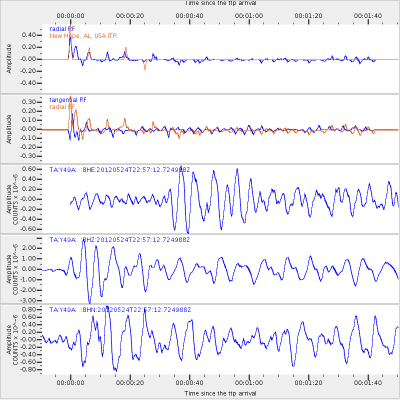
Signal To Noise
| Channel | StoN | STA | LTA |
| TA:Y49A: :BHZ:20120524T22:57:12.724988Z | 15.691613 | 1.3198196E-6 | 8.410987E-8 |
| TA:Y49A: :BHN:20120524T22:57:12.724988Z | 5.9532766 | 3.2145988E-7 | 5.399713E-8 |
| TA:Y49A: :BHE:20120524T22:57:12.724988Z | 2.3427405 | 1.7649936E-7 | 7.533884E-8 |
| Arrivals |
| Ps | 6.5 SECOND |
| PpPs | 18 SECOND |
| PsPs/PpSs | 25 SECOND |


