You are here: Home > Network List > G - GEOSCOPE Stations List
> Station RER Riviere de l'Est, La Reunion (Indian Ocean) > Earthquake Result Viewer
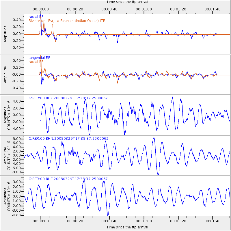
RER Riviere de l'Est, La Reunion (Indian Ocean) - Earthquake Result Viewer
*The percent match for this event was below the threshold and hence no stack was calculated.
| Earthquake location: |
Off W Coast Of Northern Sumatra |
| Earthquake latitude/longitude: |
2.9/95.3 |
| Earthquake time(UTC): |
2008/03/29 (089) 17:30:50 GMT |
| Earthquake Depth: |
20 km |
| Earthquake Magnitude: |
5.8 MB, 6.5 MS, 6.3 MW, 6.3 MW |
| Earthquake Catalog/Contributor: |
WHDF/NEIC |
|
| Network: |
G GEOSCOPE |
| Station: |
RER Riviere de l'Est, La Reunion (Indian Ocean) |
| Lat/Lon: |
21.16 S/55.75 E |
| Elevation: |
834 m |
|
| Distance: |
45.5 deg |
| Az: |
236.457 deg |
| Baz: |
63.107 deg |
| Ray Param: |
$rayparam |
*The percent match for this event was below the threshold and hence was not used in the summary stack. |
|
| Radial Match: |
54.30861 % |
| Radial Bump: |
400 |
| Transverse Match: |
38.024277 % |
| Transverse Bump: |
400 |
| SOD ConfigId: |
2504 |
| Insert Time: |
2010-02-26 23:45:26.054 +0000 |
| GWidth: |
2.5 |
| Max Bumps: |
400 |
| Tol: |
0.001 |
|
Signal To Noise
| Channel | StoN | STA | LTA |
| G:RER:00:BHN:20080329T17:38:37.250006Z | 2.019495 | 3.3354618E-6 | 1.6516315E-6 |
| G:RER:00:BHE:20080329T17:38:37.250006Z | 1.4904263 | 1.8118502E-6 | 1.215659E-6 |
| G:RER:00:BHZ:20080329T17:38:37.250006Z | 1.1266397 | 2.7009994E-6 | 2.3973942E-6 |
| Arrivals |
| Ps | |
| PpPs | |
| PsPs/PpSs | |


