You are here: Home > Network List > TA - USArray Transportable Network (new EarthScope stations) Stations List
> Station Y50A Piedmont, AL, USA > Earthquake Result Viewer
Y50A Piedmont, AL, USA - Earthquake Result Viewer
| Earthquake location: |
Norwegian Sea |
| Earthquake latitude/longitude: |
73.0/5.7 |
| Earthquake time(UTC): |
2012/05/24 (145) 22:47:46 GMT |
| Earthquake Depth: |
10 km |
| Earthquake Magnitude: |
5.7 MB, 6.1 MS, 6.1 MW, 6.2 MW |
| Earthquake Catalog/Contributor: |
WHDF/NEIC |
|
| Network: |
TA USArray Transportable Network (new EarthScope stations) |
| Station: |
Y50A Piedmont, AL, USA |
| Lat/Lon: |
33.89 N/85.73 W |
| Elevation: |
248 m |
|
| Distance: |
58.4 deg |
| Az: |
282.432 deg |
| Baz: |
20.252 deg |
| Ray Param: |
0.062882744 |
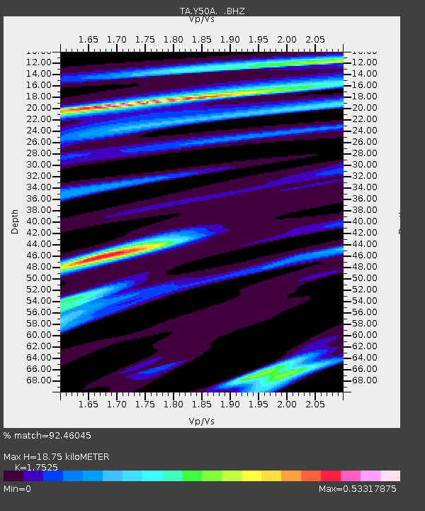
| Estimated Moho Depth: |
18.75 km |
| Estimated Crust Vp/Vs: |
1.75 |
| Assumed Crust Vp: |
6.719 km/s |
| Estimated Crust Vs: |
3.834 km/s |
| Estimated Crust Poisson's Ratio: |
0.26 |
|
| Radial Match: |
92.46045 % |
| Radial Bump: |
400 |
| Transverse Match: |
78.19031 % |
| Transverse Bump: |
400 |
| SOD ConfigId: |
446234 |
| Insert Time: |
2012-08-25 21:39:24.475 +0000 |
| GWidth: |
2.5 |
| Max Bumps: |
400 |
| Tol: |
0.001 |
|
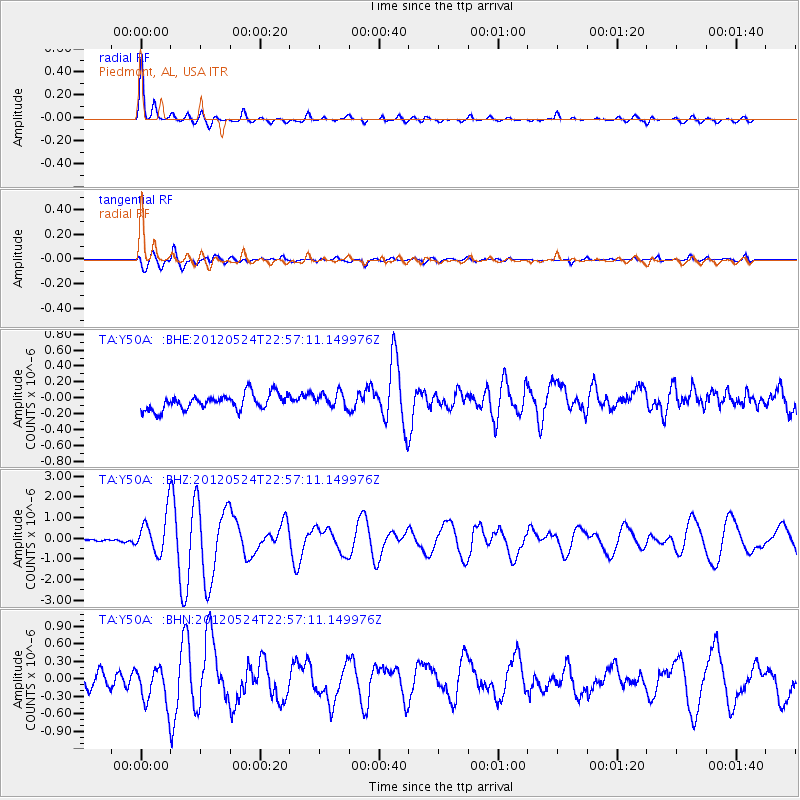
Signal To Noise
| Channel | StoN | STA | LTA |
| TA:Y50A: :BHZ:20120524T22:57:11.149976Z | 13.160831 | 9.574392E-7 | 7.274914E-8 |
| TA:Y50A: :BHN:20120524T22:57:11.149976Z | 3.8174734 | 3.2179716E-7 | 8.429585E-8 |
| TA:Y50A: :BHE:20120524T22:57:11.149976Z | 0.9528093 | 9.3826095E-8 | 9.8473116E-8 |
| Arrivals |
| Ps | 2.2 SECOND |
| PpPs | 7.3 SECOND |
| PsPs/PpSs | 9.5 SECOND |


