You are here: Home > Network List > TA - USArray Transportable Network (new EarthScope stations) Stations List
> Station 149A Jones, AL, USA > Earthquake Result Viewer
149A Jones, AL, USA - Earthquake Result Viewer
| Earthquake location: |
Norwegian Sea |
| Earthquake latitude/longitude: |
73.0/5.7 |
| Earthquake time(UTC): |
2012/05/24 (145) 22:47:46 GMT |
| Earthquake Depth: |
10 km |
| Earthquake Magnitude: |
5.7 MB, 6.1 MS, 6.1 MW, 6.2 MW |
| Earthquake Catalog/Contributor: |
WHDF/NEIC |
|
| Network: |
TA USArray Transportable Network (new EarthScope stations) |
| Station: |
149A Jones, AL, USA |
| Lat/Lon: |
32.60 N/86.79 W |
| Elevation: |
138 m |
|
| Distance: |
59.9 deg |
| Az: |
282.885 deg |
| Baz: |
19.907 deg |
| Ray Param: |
0.061889146 |
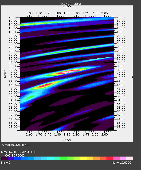
| Estimated Moho Depth: |
38.75 km |
| Estimated Crust Vp/Vs: |
1.86 |
| Assumed Crust Vp: |
6.565 km/s |
| Estimated Crust Vs: |
3.534 km/s |
| Estimated Crust Poisson's Ratio: |
0.30 |
|
| Radial Match: |
90.31507 % |
| Radial Bump: |
400 |
| Transverse Match: |
76.79576 % |
| Transverse Bump: |
400 |
| SOD ConfigId: |
446234 |
| Insert Time: |
2012-08-25 21:40:15.448 +0000 |
| GWidth: |
2.5 |
| Max Bumps: |
400 |
| Tol: |
0.001 |
|

Signal To Noise
| Channel | StoN | STA | LTA |
| TA:149A: :BHZ:20120524T22:57:21.625012Z | 9.511615 | 9.959256E-7 | 1.0470626E-7 |
| TA:149A: :BHN:20120524T22:57:21.625012Z | 4.4557767 | 5.144772E-7 | 1.15462974E-7 |
| TA:149A: :BHE:20120524T22:57:21.625012Z | 2.2932086 | 2.74444E-7 | 1.1967686E-7 |
| Arrivals |
| Ps | 5.3 SECOND |
| PpPs | 16 SECOND |
| PsPs/PpSs | 21 SECOND |


