You are here: Home > Network List > TA - USArray Transportable Network (new EarthScope stations) Stations List
> Station 554A Perry, FL, USA > Earthquake Result Viewer
554A Perry, FL, USA - Earthquake Result Viewer

| Earthquake location: |
Norwegian Sea |
| Earthquake latitude/longitude: |
73.0/5.7 |
| Earthquake time(UTC): |
2012/05/24 (145) 22:47:46 GMT |
| Earthquake Depth: |
10 km |
| Earthquake Magnitude: |
5.7 MB, 6.1 MS, 6.1 MW, 6.2 MW |
| Earthquake Catalog/Contributor: |
WHDF/NEIC |
|
| Network: |
TA USArray Transportable Network (new EarthScope stations) |
| Station: |
554A Perry, FL, USA |
| Lat/Lon: |
30.08 N/83.68 W |
| Elevation: |
12 m |
|
| Distance: |
61.4 deg |
| Az: |
279.04 deg |
| Baz: |
19.63 deg |
| Ray Param: |
0.06092714 |
| Estimated Moho Depth: |
16.0 km |
| Estimated Crust Vp/Vs: |
1.81 |
| Assumed Crust Vp: |
6.565 km/s |
| Estimated Crust Vs: |
3.632 km/s |
| Estimated Crust Poisson's Ratio: |
0.28 |
|
| Radial Match: |
88.701385 % |
| Radial Bump: |
400 |
| Transverse Match: |
78.52432 % |
| Transverse Bump: |
400 |
| SOD ConfigId: |
446234 |
| Insert Time: |
2012-08-25 21:41:20.412 +0000 |
| GWidth: |
2.5 |
| Max Bumps: |
400 |
| Tol: |
0.001 |
|
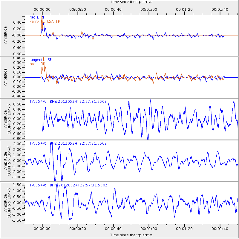
Signal To Noise
| Channel | StoN | STA | LTA |
| TA:554A: :BHZ:20120524T22:57:31.550Z | 3.205673 | 9.942316E-7 | 3.1014758E-7 |
| TA:554A: :BHN:20120524T22:57:31.550Z | 2.622754 | 3.608593E-7 | 1.3758793E-7 |
| TA:554A: :BHE:20120524T22:57:31.550Z | 0.9464222 | 1.8972857E-7 | 2.0046927E-7 |
| Arrivals |
| Ps | 2.1 SECOND |
| PpPs | 6.5 SECOND |
| PsPs/PpSs | 8.6 SECOND |


