You are here: Home > Network List > TA - USArray Transportable Network (new EarthScope stations) Stations List
> Station 253A Americus, GA, USA > Earthquake Result Viewer
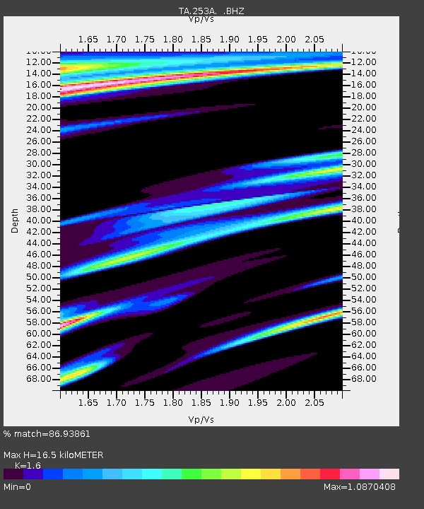
253A Americus, GA, USA - Earthquake Result Viewer
| Earthquake location: |
Norwegian Sea |
| Earthquake latitude/longitude: |
73.0/5.7 |
| Earthquake time(UTC): |
2012/05/24 (145) 22:47:46 GMT |
| Earthquake Depth: |
10 km |
| Earthquake Magnitude: |
5.7 MB, 6.1 MS, 6.1 MW, 6.2 MW |
| Earthquake Catalog/Contributor: |
WHDF/NEIC |
|
| Network: |
TA USArray Transportable Network (new EarthScope stations) |
| Station: |
253A Americus, GA, USA |
| Lat/Lon: |
32.06 N/84.13 W |
| Elevation: |
136 m |
|
| Distance: |
59.6 deg |
| Az: |
280.221 deg |
| Baz: |
19.983 deg |
| Ray Param: |
0.062062368 |
| Estimated Moho Depth: |
16.5 km |
| Estimated Crust Vp/Vs: |
1.60 |
| Assumed Crust Vp: |
6.719 km/s |
| Estimated Crust Vs: |
4.2 km/s |
| Estimated Crust Poisson's Ratio: |
0.18 |
|
| Radial Match: |
86.93861 % |
| Radial Bump: |
400 |
| Transverse Match: |
81.65676 % |
| Transverse Bump: |
400 |
| SOD ConfigId: |
446234 |
| Insert Time: |
2012-08-25 21:41:50.524 +0000 |
| GWidth: |
2.5 |
| Max Bumps: |
400 |
| Tol: |
0.001 |
|

Signal To Noise
| Channel | StoN | STA | LTA |
| TA:253A: :BHZ:20120524T22:57:19.800Z | 6.868102 | 1.275374E-6 | 1.8569526E-7 |
| TA:253A: :BHN:20120524T22:57:19.800Z | 2.0591898 | 4.551393E-7 | 2.2102833E-7 |
| TA:253A: :BHE:20120524T22:57:19.800Z | 1.6244613 | 6.039974E-7 | 3.71814E-7 |
| Arrivals |
| Ps | 1.6 SECOND |
| PpPs | 6.0 SECOND |
| PsPs/PpSs | 7.6 SECOND |


