You are here: Home > Network List > TA - USArray Transportable Network (new EarthScope stations) Stations List
> Station 155A Kite, GA, USA > Earthquake Result Viewer
155A Kite, GA, USA - Earthquake Result Viewer
| Earthquake location: |
Norwegian Sea |
| Earthquake latitude/longitude: |
73.0/5.7 |
| Earthquake time(UTC): |
2012/05/24 (145) 22:47:46 GMT |
| Earthquake Depth: |
10 km |
| Earthquake Magnitude: |
5.7 MB, 6.1 MS, 6.1 MW, 6.2 MW |
| Earthquake Catalog/Contributor: |
WHDF/NEIC |
|
| Network: |
TA USArray Transportable Network (new EarthScope stations) |
| Station: |
155A Kite, GA, USA |
| Lat/Lon: |
32.62 N/82.47 W |
| Elevation: |
93 m |
|
| Distance: |
58.6 deg |
| Az: |
278.905 deg |
| Baz: |
20.193 deg |
| Ray Param: |
0.06272568 |
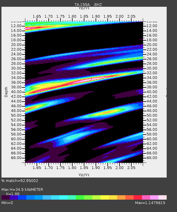
| Estimated Moho Depth: |
34.5 km |
| Estimated Crust Vp/Vs: |
1.88 |
| Assumed Crust Vp: |
6.565 km/s |
| Estimated Crust Vs: |
3.492 km/s |
| Estimated Crust Poisson's Ratio: |
0.30 |
|
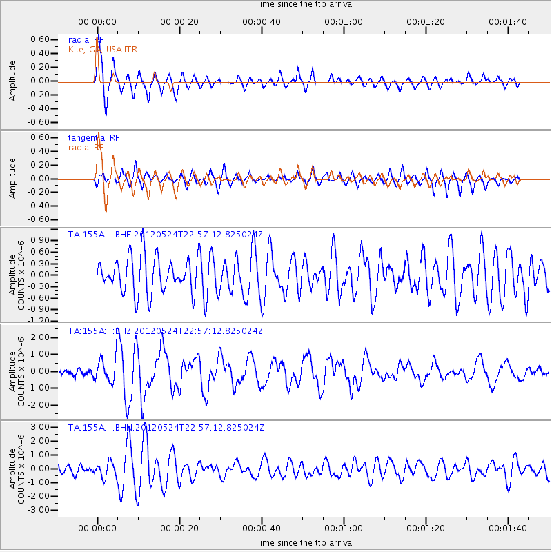
| Radial Match: |
92.95002 % |
| Radial Bump: |
400 |
| Transverse Match: |
59.763603 % |
| Transverse Bump: |
342 |
| SOD ConfigId: |
446234 |
| Insert Time: |
2012-08-25 21:42:26.531 +0000 |
| GWidth: |
2.5 |
| Max Bumps: |
400 |
| Tol: |
0.001 |
|
Signal To Noise
| Channel | StoN | STA | LTA |
| TA:155A: :BHZ:20120524T22:57:12.825024Z | 5.561014 | 7.600763E-7 | 1.3667945E-7 |
| TA:155A: :BHN:20120524T22:57:12.825024Z | 2.2122438 | 5.4067226E-7 | 2.4439993E-7 |
| TA:155A: :BHE:20120524T22:57:12.825024Z | 0.81809294 | 3.7909714E-7 | 4.633913E-7 |
| Arrivals |
| Ps | 4.9 SECOND |
| PpPs | 14 SECOND |
| PsPs/PpSs | 19 SECOND |


