You are here: Home > Network List > G - GEOSCOPE Stations List
> Station RER Riviere de l'Est, La Reunion (Indian Ocean) > Earthquake Result Viewer
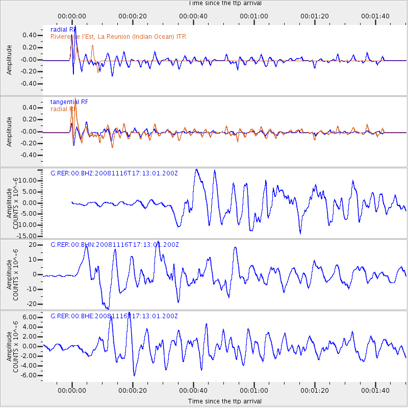
RER Riviere de l'Est, La Reunion (Indian Ocean) - Earthquake Result Viewer
*The percent match for this event was below the threshold and hence no stack was calculated.
| Earthquake location: |
Minahassa Peninsula, Sulawesi |
| Earthquake latitude/longitude: |
1.3/122.1 |
| Earthquake time(UTC): |
2008/11/16 (321) 17:02:32 GMT |
| Earthquake Depth: |
30 km |
| Earthquake Magnitude: |
6.5 MB, 7.0 MS, 7.3 MW, 7.3 MW |
| Earthquake Catalog/Contributor: |
WHDF/NEIC |
|
| Network: |
G GEOSCOPE |
| Station: |
RER Riviere de l'Est, La Reunion (Indian Ocean) |
| Lat/Lon: |
21.16 S/55.75 E |
| Elevation: |
834 m |
|
| Distance: |
68.5 deg |
| Az: |
246.767 deg |
| Baz: |
79.816 deg |
| Ray Param: |
$rayparam |
*The percent match for this event was below the threshold and hence was not used in the summary stack. |
|
| Radial Match: |
86.17018 % |
| Radial Bump: |
400 |
| Transverse Match: |
79.57796 % |
| Transverse Bump: |
400 |
| SOD ConfigId: |
2658 |
| Insert Time: |
2010-02-26 23:45:33.769 +0000 |
| GWidth: |
2.5 |
| Max Bumps: |
400 |
| Tol: |
0.001 |
|
Signal To Noise
| Channel | StoN | STA | LTA |
| G:RER:00:BHN:20081116T17:13:01.200Z | 22.303736 | 8.6013415E-6 | 3.8564576E-7 |
| G:RER:00:BHE:20081116T17:13:01.200Z | 2.2151077 | 5.8063074E-7 | 2.6212302E-7 |
| G:RER:00:BHZ:20081116T17:13:01.200Z | 5.0080504 | 3.6204651E-6 | 7.229291E-7 |
| Arrivals |
| Ps | |
| PpPs | |
| PsPs/PpSs | |


