You are here: Home > Network List > TA - USArray Transportable Network (new EarthScope stations) Stations List
> Station Z52A Williamson, GA, USA > Earthquake Result Viewer
Z52A Williamson, GA, USA - Earthquake Result Viewer

| Earthquake location: |
Norwegian Sea |
| Earthquake latitude/longitude: |
73.0/5.7 |
| Earthquake time(UTC): |
2012/05/24 (145) 22:47:46 GMT |
| Earthquake Depth: |
10 km |
| Earthquake Magnitude: |
5.7 MB, 6.1 MS, 6.1 MW, 6.2 MW |
| Earthquake Catalog/Contributor: |
WHDF/NEIC |
|
| Network: |
TA USArray Transportable Network (new EarthScope stations) |
| Station: |
Z52A Williamson, GA, USA |
| Lat/Lon: |
33.19 N/84.42 W |
| Elevation: |
252 m |
|
| Distance: |
58.7 deg |
| Az: |
280.937 deg |
| Baz: |
20.196 deg |
| Ray Param: |
0.06270248 |
| Estimated Moho Depth: |
42.5 km |
| Estimated Crust Vp/Vs: |
1.76 |
| Assumed Crust Vp: |
6.719 km/s |
| Estimated Crust Vs: |
3.807 km/s |
| Estimated Crust Poisson's Ratio: |
0.26 |
|
| Radial Match: |
96.46099 % |
| Radial Bump: |
258 |
| Transverse Match: |
85.98054 % |
| Transverse Bump: |
400 |
| SOD ConfigId: |
446234 |
| Insert Time: |
2012-08-25 21:43:14.664 +0000 |
| GWidth: |
2.5 |
| Max Bumps: |
400 |
| Tol: |
0.001 |
|
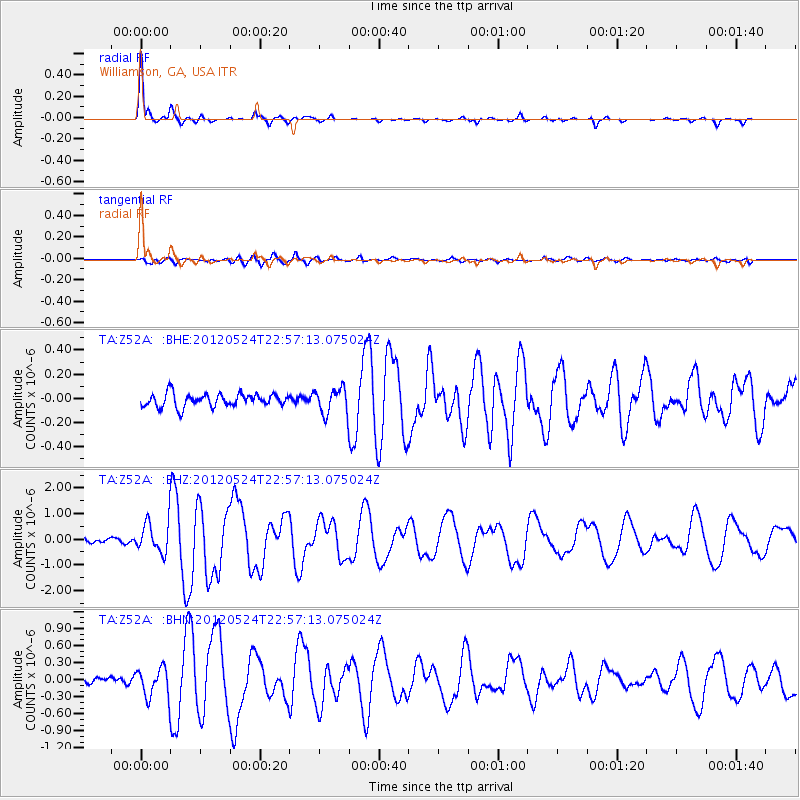
Signal To Noise
| Channel | StoN | STA | LTA |
| TA:Z52A: :BHZ:20120524T22:57:13.075024Z | 8.380534 | 6.1345446E-7 | 7.319993E-8 |
| TA:Z52A: :BHN:20120524T22:57:13.075024Z | 4.926229 | 2.6144042E-7 | 5.3071105E-8 |
| TA:Z52A: :BHE:20120524T22:57:13.075024Z | 1.9547842 | 1.0578794E-7 | 5.4117457E-8 |
| Arrivals |
| Ps | 5.1 SECOND |
| PpPs | 17 SECOND |
| PsPs/PpSs | 22 SECOND |


