You are here: Home > Network List > TA - USArray Transportable Network (new EarthScope stations) Stations List
> Station Z54A Sparta, GA, USA > Earthquake Result Viewer
Z54A Sparta, GA, USA - Earthquake Result Viewer
| Earthquake location: |
Norwegian Sea |
| Earthquake latitude/longitude: |
73.0/5.7 |
| Earthquake time(UTC): |
2012/05/24 (145) 22:47:46 GMT |
| Earthquake Depth: |
10 km |
| Earthquake Magnitude: |
5.7 MB, 6.1 MS, 6.1 MW, 6.2 MW |
| Earthquake Catalog/Contributor: |
WHDF/NEIC |
|
| Network: |
TA USArray Transportable Network (new EarthScope stations) |
| Station: |
Z54A Sparta, GA, USA |
| Lat/Lon: |
33.24 N/82.84 W |
| Elevation: |
134 m |
|
| Distance: |
58.2 deg |
| Az: |
279.501 deg |
| Baz: |
20.302 deg |
| Ray Param: |
0.06302918 |
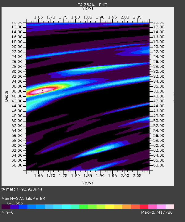
| Estimated Moho Depth: |
37.5 km |
| Estimated Crust Vp/Vs: |
1.66 |
| Assumed Crust Vp: |
6.565 km/s |
| Estimated Crust Vs: |
3.943 km/s |
| Estimated Crust Poisson's Ratio: |
0.22 |
|
| Radial Match: |
92.920944 % |
| Radial Bump: |
400 |
| Transverse Match: |
82.1661 % |
| Transverse Bump: |
400 |
| SOD ConfigId: |
446234 |
| Insert Time: |
2012-08-25 21:43:25.995 +0000 |
| GWidth: |
2.5 |
| Max Bumps: |
400 |
| Tol: |
0.001 |
|
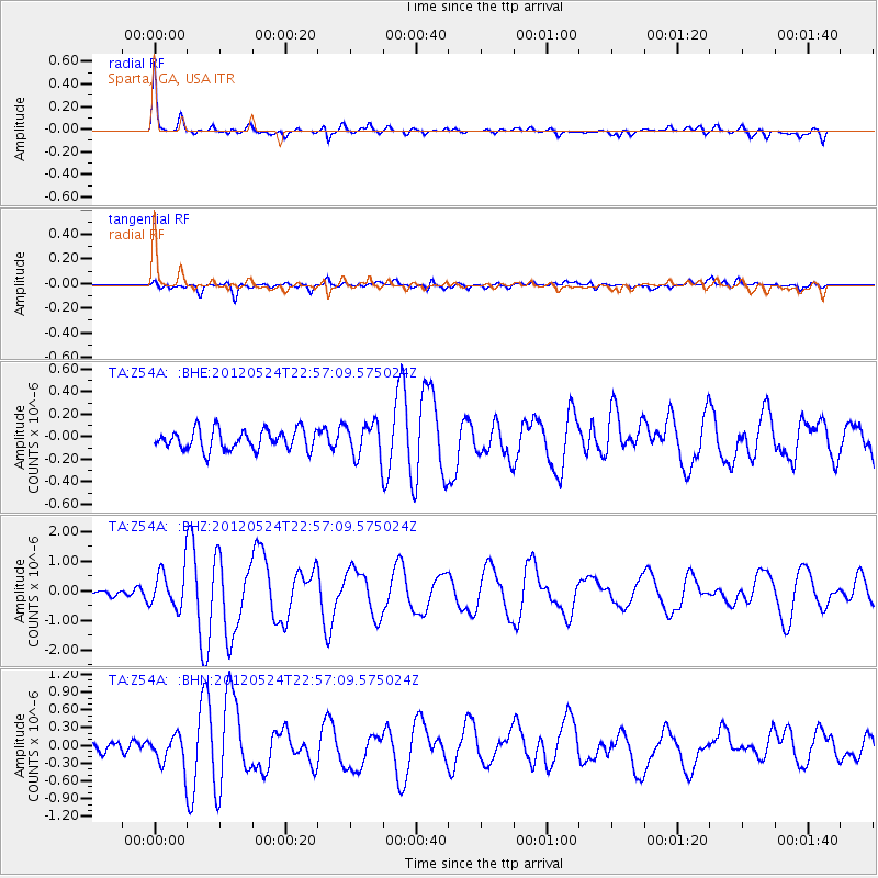
Signal To Noise
| Channel | StoN | STA | LTA |
| TA:Z54A: :BHZ:20120524T22:57:09.575024Z | 5.8089743 | 6.4991787E-7 | 1.1188169E-7 |
| TA:Z54A: :BHN:20120524T22:57:09.575024Z | 2.9091969 | 2.5615753E-7 | 8.8050946E-8 |
| TA:Z54A: :BHE:20120524T22:57:09.575024Z | 1.6831561 | 1.5053024E-7 | 8.943332E-8 |
| Arrivals |
| Ps | 4.0 SECOND |
| PpPs | 14 SECOND |
| PsPs/PpSs | 18 SECOND |


