You are here: Home > Network List > TA - USArray Transportable Network (new EarthScope stations) Stations List
> Station Y53A Monroe, GA, USA > Earthquake Result Viewer
Y53A Monroe, GA, USA - Earthquake Result Viewer
| Earthquake location: |
Norwegian Sea |
| Earthquake latitude/longitude: |
73.0/5.7 |
| Earthquake time(UTC): |
2012/05/24 (145) 22:47:46 GMT |
| Earthquake Depth: |
10 km |
| Earthquake Magnitude: |
5.7 MB, 6.1 MS, 6.1 MW, 6.2 MW |
| Earthquake Catalog/Contributor: |
WHDF/NEIC |
|
| Network: |
TA USArray Transportable Network (new EarthScope stations) |
| Station: |
Y53A Monroe, GA, USA |
| Lat/Lon: |
33.86 N/83.58 W |
| Elevation: |
234 m |
|
| Distance: |
57.8 deg |
| Az: |
280.44 deg |
| Baz: |
20.392 deg |
| Ray Param: |
0.063265845 |
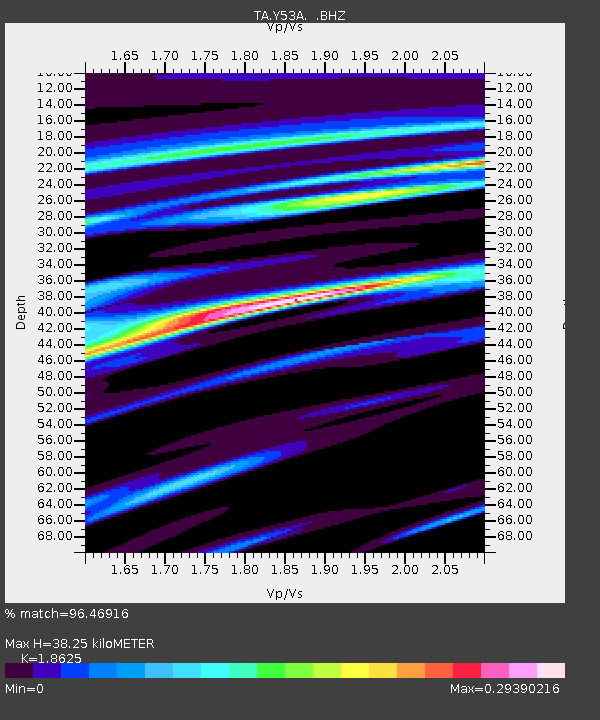
| Estimated Moho Depth: |
38.25 km |
| Estimated Crust Vp/Vs: |
1.86 |
| Assumed Crust Vp: |
6.565 km/s |
| Estimated Crust Vs: |
3.525 km/s |
| Estimated Crust Poisson's Ratio: |
0.30 |
|
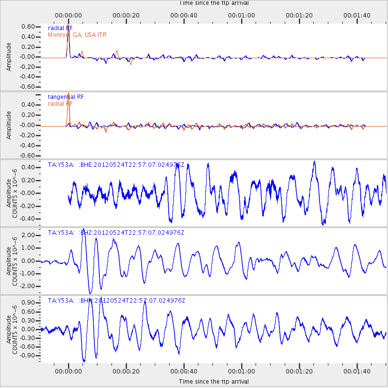
| Radial Match: |
96.46916 % |
| Radial Bump: |
263 |
| Transverse Match: |
82.27456 % |
| Transverse Bump: |
400 |
| SOD ConfigId: |
446234 |
| Insert Time: |
2012-08-25 21:43:50.075 +0000 |
| GWidth: |
2.5 |
| Max Bumps: |
400 |
| Tol: |
0.001 |
|
Signal To Noise
| Channel | StoN | STA | LTA |
| TA:Y53A: :BHZ:20120524T22:57:07.024976Z | 5.584823 | 6.2150394E-7 | 1.1128444E-7 |
| TA:Y53A: :BHN:20120524T22:57:07.024976Z | 3.5857453 | 2.3615415E-7 | 6.5859155E-8 |
| TA:Y53A: :BHE:20120524T22:57:07.024976Z | 1.4083288 | 1.3405918E-7 | 9.519026E-8 |
| Arrivals |
| Ps | 5.3 SECOND |
| PpPs | 16 SECOND |
| PsPs/PpSs | 21 SECOND |


