You are here: Home > Network List > TA - USArray Transportable Network (new EarthScope stations) Stations List
> Station V52A Sevierville, TN, USA > Earthquake Result Viewer
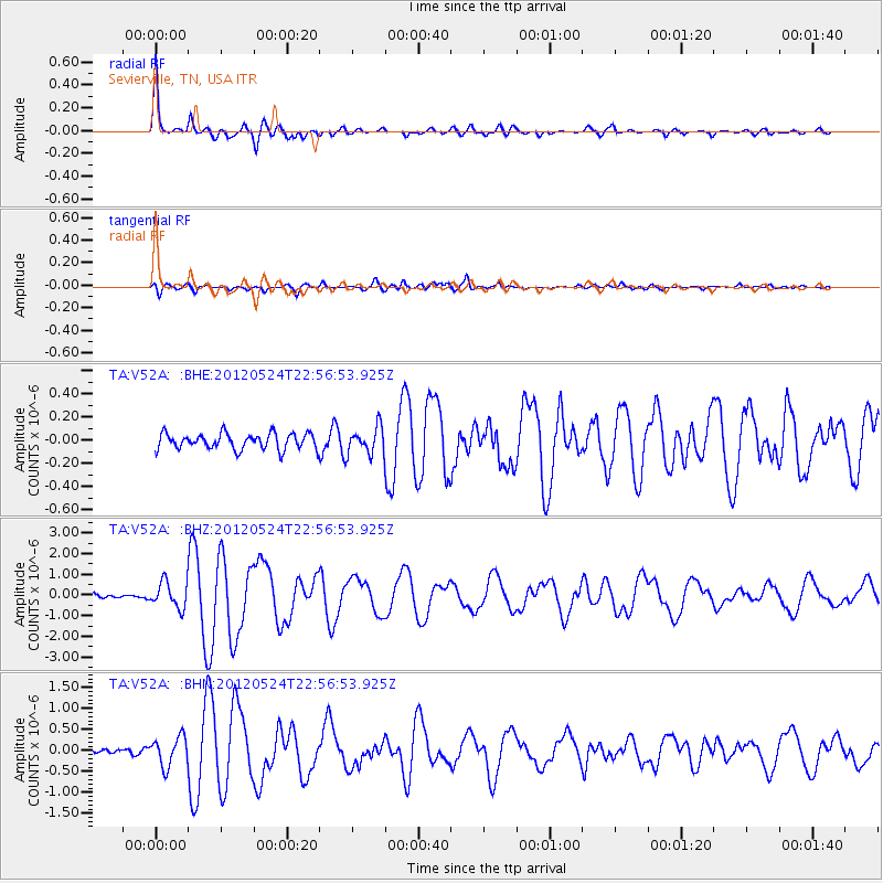
V52A Sevierville, TN, USA - Earthquake Result Viewer

| Earthquake location: |
Norwegian Sea |
| Earthquake latitude/longitude: |
73.0/5.7 |
| Earthquake time(UTC): |
2012/05/24 (145) 22:47:46 GMT |
| Earthquake Depth: |
10 km |
| Earthquake Magnitude: |
5.7 MB, 6.1 MS, 6.1 MW, 6.2 MW |
| Earthquake Catalog/Contributor: |
WHDF/NEIC |
|
| Network: |
TA USArray Transportable Network (new EarthScope stations) |
| Station: |
V52A Sevierville, TN, USA |
| Lat/Lon: |
35.84 N/83.60 W |
| Elevation: |
328 m |
|
| Distance: |
55.9 deg |
| Az: |
281.284 deg |
| Baz: |
20.847 deg |
| Ray Param: |
0.06446639 |
| Estimated Moho Depth: |
39.0 km |
| Estimated Crust Vp/Vs: |
1.82 |
| Assumed Crust Vp: |
6.35 km/s |
| Estimated Crust Vs: |
3.484 km/s |
| Estimated Crust Poisson's Ratio: |
0.28 |
|
| Radial Match: |
96.24959 % |
| Radial Bump: |
395 |
| Transverse Match: |
83.668205 % |
| Transverse Bump: |
400 |
| SOD ConfigId: |
446234 |
| Insert Time: |
2012-08-25 21:44:21.417 +0000 |
| GWidth: |
2.5 |
| Max Bumps: |
400 |
| Tol: |
0.001 |
|
Signal To Noise
| Channel | StoN | STA | LTA |
| TA:V52A: :BHZ:20120524T22:56:53.925Z | 5.1806636 | 6.192819E-7 | 1.1953718E-7 |
| TA:V52A: :BHN:20120524T22:56:53.925Z | 6.2387605 | 3.4638862E-7 | 5.5522026E-8 |
| TA:V52A: :BHE:20120524T22:56:53.925Z | 1.6751431 | 1.1408338E-7 | 6.810366E-8 |
| Arrivals |
| Ps | 5.3 SECOND |
| PpPs | 17 SECOND |
| PsPs/PpSs | 22 SECOND |


