You are here: Home > Network List > YE11 - Testing TA and FA Vaults and Directly Buried Sensors (3T) Stations List
> Station DBT2A Socorro, NM > Earthquake Result Viewer
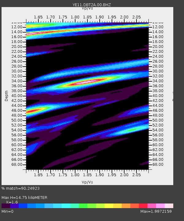
DBT2A Socorro, NM - Earthquake Result Viewer
| Earthquake location: |
Norwegian Sea |
| Earthquake latitude/longitude: |
73.0/5.7 |
| Earthquake time(UTC): |
2012/05/24 (145) 22:47:46 GMT |
| Earthquake Depth: |
10 km |
| Earthquake Magnitude: |
5.7 MB, 6.1 MS, 6.1 MW, 6.2 MW |
| Earthquake Catalog/Contributor: |
WHDF/NEIC |
|
| Network: |
YE Testing TA and FA Vaults and Directly Buried Sensors (3T) |
| Station: |
DBT2A Socorro, NM |
| Lat/Lon: |
33.96 N/106.85 W |
| Elevation: |
1396 m |
|
| Distance: |
64.1 deg |
| Az: |
301.378 deg |
| Baz: |
17.629 deg |
| Ray Param: |
0.059166405 |
| Estimated Moho Depth: |
14.75 km |
| Estimated Crust Vp/Vs: |
1.60 |
| Assumed Crust Vp: |
6.502 km/s |
| Estimated Crust Vs: |
4.063 km/s |
| Estimated Crust Poisson's Ratio: |
0.18 |
|
| Radial Match: |
90.24923 % |
| Radial Bump: |
400 |
| Transverse Match: |
80.46766 % |
| Transverse Bump: |
400 |
| SOD ConfigId: |
446234 |
| Insert Time: |
2012-08-25 21:50:08.685 +0000 |
| GWidth: |
2.5 |
| Max Bumps: |
400 |
| Tol: |
0.001 |
|

Signal To Noise
| Channel | StoN | STA | LTA |
| YE:DBT2A:00:BHZ:20120524T22:57:49.594983Z | 5.5086637 | 6.9575765E-7 | 1.2630244E-7 |
| YE:DBT2A:00:BHN:20120524T22:57:49.594983Z | 1.4241265 | 6.46207E-7 | 4.5375674E-7 |
| YE:DBT2A:00:BHE:20120524T22:57:49.594983Z | 1.2777089 | 4.9687975E-7 | 3.8888336E-7 |
| Arrivals |
| Ps | 1.4 SECOND |
| PpPs | 5.6 SECOND |
| PsPs/PpSs | 7.0 SECOND |


