You are here: Home > Network List > G - GEOSCOPE Stations List
> Station RER Riviere de l'Est, La Reunion (Indian Ocean) > Earthquake Result Viewer
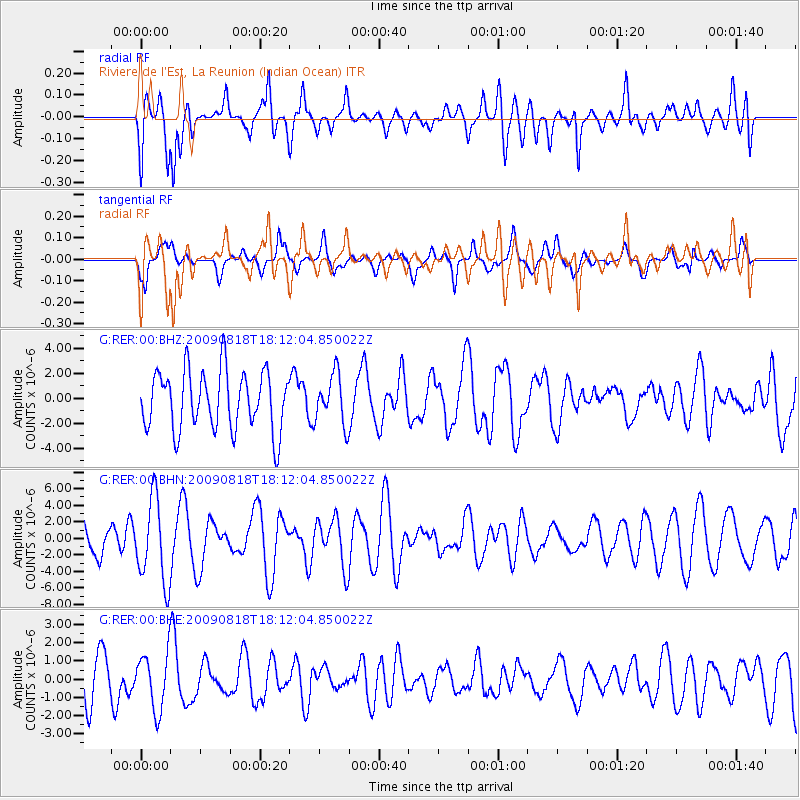
RER Riviere de l'Est, La Reunion (Indian Ocean) - Earthquake Result Viewer
*The percent match for this event was below the threshold and hence no stack was calculated.
| Earthquake location: |
Solomon Islands |
| Earthquake latitude/longitude: |
-6.6/154.6 |
| Earthquake time(UTC): |
2009/08/18 (230) 17:59:13 GMT |
| Earthquake Depth: |
35 km |
| Earthquake Magnitude: |
5.6 MW, 5.4 MS, 5.3 MB, 5.6 MW |
| Earthquake Catalog/Contributor: |
WHDF/NEIC |
|
| Network: |
G GEOSCOPE |
| Station: |
RER Riviere de l'Est, La Reunion (Indian Ocean) |
| Lat/Lon: |
21.16 S/55.75 E |
| Elevation: |
834 m |
|
| Distance: |
95.8 deg |
| Az: |
247.986 deg |
| Baz: |
99.358 deg |
| Ray Param: |
$rayparam |
*The percent match for this event was below the threshold and hence was not used in the summary stack. |
|
| Radial Match: |
68.66303 % |
| Radial Bump: |
400 |
| Transverse Match: |
64.006966 % |
| Transverse Bump: |
400 |
| SOD ConfigId: |
2622 |
| Insert Time: |
2010-02-26 23:45:41.911 +0000 |
| GWidth: |
2.5 |
| Max Bumps: |
400 |
| Tol: |
0.001 |
|
Signal To Noise
| Channel | StoN | STA | LTA |
| G:RER:00:BHN:20090818T18:12:04.850022Z | 2.166264 | 5.070873E-6 | 2.340838E-6 |
| G:RER:00:BHE:20090818T18:12:04.850022Z | 1.3944204 | 1.5507733E-6 | 1.1121275E-6 |
| G:RER:00:BHZ:20090818T18:12:04.850022Z | 0.84330404 | 2.0029775E-6 | 2.3751545E-6 |
| Arrivals |
| Ps | |
| PpPs | |
| PsPs/PpSs | |


