You are here: Home > Network List > CB - China National Seismic Network Stations List
> Station GOM Geermu,Qinghai Province > Earthquake Result Viewer
GOM Geermu,Qinghai Province - Earthquake Result Viewer
| Earthquake location: |
Bonin Islands, Japan Region |
| Earthquake latitude/longitude: |
26.9/140.1 |
| Earthquake time(UTC): |
2012/05/26 (147) 21:48:10 GMT |
| Earthquake Depth: |
487 km |
| Earthquake Magnitude: |
5.5 MB, 6.0 MW, 6.0 MW |
| Earthquake Catalog/Contributor: |
WHDF/NEIC |
|
| Network: |
CB China National Seismic Network |
| Station: |
GOM Geermu,Qinghai Province |
| Lat/Lon: |
36.20 N/94.81 E |
| Elevation: |
3121 m |
|
| Distance: |
39.4 deg |
| Az: |
295.068 deg |
| Baz: |
90.504 deg |
| Ray Param: |
0.072716214 |
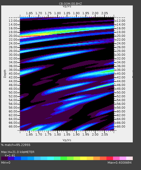
| Estimated Moho Depth: |
21.0 km |
| Estimated Crust Vp/Vs: |
1.61 |
| Assumed Crust Vp: |
6.385 km/s |
| Estimated Crust Vs: |
3.966 km/s |
| Estimated Crust Poisson's Ratio: |
0.19 |
|
| Radial Match: |
95.22955 % |
| Radial Bump: |
296 |
| Transverse Match: |
87.3981 % |
| Transverse Bump: |
400 |
| SOD ConfigId: |
446234 |
| Insert Time: |
2012-08-25 21:54:47.414 +0000 |
| GWidth: |
2.5 |
| Max Bumps: |
400 |
| Tol: |
0.001 |
|

Signal To Noise
| Channel | StoN | STA | LTA |
| CB:GOM:00:BHZ:20120526T21:54:25.949987Z | 35.47561 | 2.7774906E-6 | 7.829296E-8 |
| CB:GOM:00:BHN:20120526T21:54:25.949987Z | 9.890674 | 3.4513297E-7 | 3.4894793E-8 |
| CB:GOM:00:BHE:20120526T21:54:25.949987Z | 44.171116 | 1.006587E-6 | 2.2788356E-8 |
| Arrivals |
| Ps | 2.2 SECOND |
| PpPs | 8.0 SECOND |
| PsPs/PpSs | 10 SECOND |


