You are here: Home > Network List > G - GEOSCOPE Stations List
> Station RER Riviere de l'Est, La Reunion (Indian Ocean) > Earthquake Result Viewer
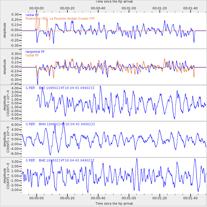
RER Riviere de l'Est, La Reunion (Indian Ocean) - Earthquake Result Viewer
*The percent match for this event was below the threshold and hence no stack was calculated.
| Earthquake location: |
Irian Jaya Region, Indonesia |
| Earthquake latitude/longitude: |
-0.9/137.3 |
| Earthquake time(UTC): |
1996/02/24 (055) 15:52:59 GMT |
| Earthquake Depth: |
33 km |
| Earthquake Magnitude: |
5.6 MB, 5.9 MS, 6.2 UNKNOWN, 6.2 MW |
| Earthquake Catalog/Contributor: |
WHDF/NEIC |
|
| Network: |
G GEOSCOPE |
| Station: |
RER Riviere de l'Est, La Reunion (Indian Ocean) |
| Lat/Lon: |
21.16 S/55.75 E |
| Elevation: |
834 m |
|
| Distance: |
81.8 deg |
| Az: |
248.88 deg |
| Baz: |
87.811 deg |
| Ray Param: |
$rayparam |
*The percent match for this event was below the threshold and hence was not used in the summary stack. |
|
| Radial Match: |
56.765774 % |
| Radial Bump: |
400 |
| Transverse Match: |
68.66981 % |
| Transverse Bump: |
400 |
| SOD ConfigId: |
4480 |
| Insert Time: |
2010-02-26 23:45:45.844 +0000 |
| GWidth: |
2.5 |
| Max Bumps: |
400 |
| Tol: |
0.001 |
|
Signal To Noise
| Channel | StoN | STA | LTA |
| G:RER: :BHN:19960224T16:04:43.949023Z | 1.2954994 | 1.4492941E-6 | 1.1187146E-6 |
| G:RER: :BHE:19960224T16:04:43.949023Z | 0.8418158 | 9.955684E-7 | 1.1826439E-6 |
| G:RER: :BHZ:19960224T16:04:43.949023Z | 0.7281521 | 1.1016873E-6 | 1.5129906E-6 |
| Arrivals |
| Ps | |
| PpPs | |
| PsPs/PpSs | |


