You are here: Home > Network List > CI - Caltech Regional Seismic Network Stations List
> Station GMR Granite Mountains Research Center > Earthquake Result Viewer
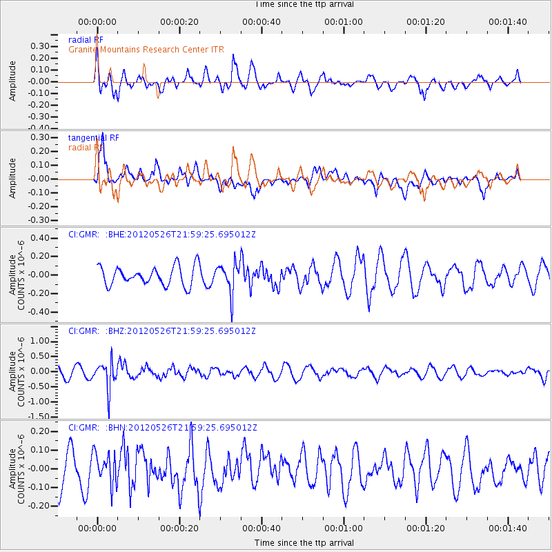
GMR Granite Mountains Research Center - Earthquake Result Viewer
*The percent match for this event was below the threshold and hence no stack was calculated.
| Earthquake location: |
Bonin Islands, Japan Region |
| Earthquake latitude/longitude: |
26.9/140.1 |
| Earthquake time(UTC): |
2012/05/26 (147) 21:48:10 GMT |
| Earthquake Depth: |
487 km |
| Earthquake Magnitude: |
5.5 MB, 6.0 MW, 6.0 MW |
| Earthquake Catalog/Contributor: |
WHDF/NEIC |
|
| Network: |
CI Caltech Regional Seismic Network |
| Station: |
GMR Granite Mountains Research Center |
| Lat/Lon: |
34.78 N/115.66 W |
| Elevation: |
1326 m |
|
| Distance: |
85.7 deg |
| Az: |
53.116 deg |
| Baz: |
299.804 deg |
| Ray Param: |
$rayparam |
*The percent match for this event was below the threshold and hence was not used in the summary stack. |
|
| Radial Match: |
65.35735 % |
| Radial Bump: |
400 |
| Transverse Match: |
72.885635 % |
| Transverse Bump: |
400 |
| SOD ConfigId: |
446234 |
| Insert Time: |
2012-08-25 21:57:24.396 +0000 |
| GWidth: |
2.5 |
| Max Bumps: |
400 |
| Tol: |
0.001 |
|
Signal To Noise
| Channel | StoN | STA | LTA |
| CI:GMR: :BHZ:20120526T21:59:25.695012Z | 3.0273433 | 4.5756684E-7 | 1.5114468E-7 |
| CI:GMR: :BHN:20120526T21:59:25.695012Z | 0.49520907 | 8.0190354E-8 | 1.6193232E-7 |
| CI:GMR: :BHE:20120526T21:59:25.695012Z | 1.6128795 | 1.6515469E-7 | 1.02397415E-7 |
| Arrivals |
| Ps | |
| PpPs | |
| PsPs/PpSs | |


