You are here: Home > Network List > II - Global Seismograph Network (GSN - IRIS/IDA) Stations List
> Station TAU Hobart, Tasmania, Australia > Earthquake Result Viewer
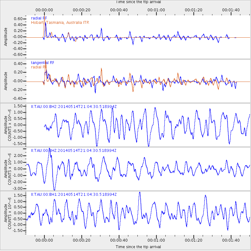
TAU Hobart, Tasmania, Australia - Earthquake Result Viewer
*The percent match for this event was below the threshold and hence no stack was calculated.
| Earthquake location: |
E. Caroline Islands, Micronesia |
| Earthquake latitude/longitude: |
6.5/144.9 |
| Earthquake time(UTC): |
2014/05/14 (134) 20:56:13 GMT |
| Earthquake Depth: |
10 km |
| Earthquake Magnitude: |
6.1 MI |
| Earthquake Catalog/Contributor: |
NEIC PDE/NEIC ALERT |
|
| Network: |
II Global Seismograph Network (GSN - IRIS/IDA) |
| Station: |
TAU Hobart, Tasmania, Australia |
| Lat/Lon: |
42.91 S/147.32 E |
| Elevation: |
132 m |
|
| Distance: |
49.2 deg |
| Az: |
177.628 deg |
| Baz: |
356.791 deg |
| Ray Param: |
$rayparam |
*The percent match for this event was below the threshold and hence was not used in the summary stack. |
|
| Radial Match: |
75.3185 % |
| Radial Bump: |
400 |
| Transverse Match: |
70.083 % |
| Transverse Bump: |
400 |
| SOD ConfigId: |
3390531 |
| Insert Time: |
2019-04-11 21:29:31.339 +0000 |
| GWidth: |
2.5 |
| Max Bumps: |
400 |
| Tol: |
0.001 |
|
Signal To Noise
| Channel | StoN | STA | LTA |
| II:TAU:00:BHZ:20140514T21:04:30.518994Z | 2.2925649 | 1.7749841E-6 | 7.742351E-7 |
| II:TAU:00:BH1:20140514T21:04:30.518994Z | 0.9926966 | 4.2586447E-7 | 4.2899762E-7 |
| II:TAU:00:BH2:20140514T21:04:30.518994Z | 1.5939612 | 7.6367775E-7 | 4.7910686E-7 |
| Arrivals |
| Ps | |
| PpPs | |
| PsPs/PpSs | |


