You are here: Home > Network List > TA - USArray Transportable Network (new EarthScope stations) Stations List
> Station L04D Klamath Falls, OR, USA > Earthquake Result Viewer
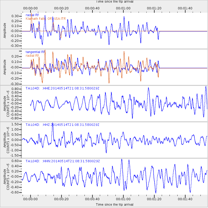
L04D Klamath Falls, OR, USA - Earthquake Result Viewer
*The percent match for this event was below the threshold and hence no stack was calculated.
| Earthquake location: |
E. Caroline Islands, Micronesia |
| Earthquake latitude/longitude: |
6.5/144.9 |
| Earthquake time(UTC): |
2014/05/14 (134) 20:56:13 GMT |
| Earthquake Depth: |
10 km |
| Earthquake Magnitude: |
6.1 MI |
| Earthquake Catalog/Contributor: |
NEIC PDE/NEIC ALERT |
|
| Network: |
TA USArray Transportable Network (new EarthScope stations) |
| Station: |
L04D Klamath Falls, OR, USA |
| Lat/Lon: |
42.22 N/122.30 W |
| Elevation: |
1437 m |
|
| Distance: |
87.8 deg |
| Az: |
47.944 deg |
| Baz: |
276.65 deg |
| Ray Param: |
$rayparam |
*The percent match for this event was below the threshold and hence was not used in the summary stack. |
|
| Radial Match: |
70.88254 % |
| Radial Bump: |
400 |
| Transverse Match: |
57.341125 % |
| Transverse Bump: |
400 |
| SOD ConfigId: |
3390531 |
| Insert Time: |
2019-04-11 21:30:35.322 +0000 |
| GWidth: |
2.5 |
| Max Bumps: |
400 |
| Tol: |
0.001 |
|
Signal To Noise
| Channel | StoN | STA | LTA |
| TA:L04D: :HHZ:20140514T21:08:31.580029Z | 1.5913221 | 1.8842995E-7 | 1.1841095E-7 |
| TA:L04D: :HHN:20140514T21:08:31.580029Z | 0.8713849 | 1.1517655E-7 | 1.3217644E-7 |
| TA:L04D: :HHE:20140514T21:08:31.580029Z | 1.4341311 | 2.4666107E-7 | 1.7199338E-7 |
| Arrivals |
| Ps | |
| PpPs | |
| PsPs/PpSs | |


