You are here: Home > Network List > TA - USArray Transportable Network (new EarthScope stations) Stations List
> Station F35A Swanville, MN, USA > Earthquake Result Viewer
F35A Swanville, MN, USA - Earthquake Result Viewer
*The percent match for this event was below the threshold and hence no stack was calculated.
| Earthquake location: |
Bonin Islands, Japan Region |
| Earthquake latitude/longitude: |
26.9/140.1 |
| Earthquake time(UTC): |
2012/05/26 (147) 21:48:10 GMT |
| Earthquake Depth: |
487 km |
| Earthquake Magnitude: |
5.5 MB, 6.0 MW, 6.0 MW |
| Earthquake Catalog/Contributor: |
WHDF/NEIC |
|
| Network: |
TA USArray Transportable Network (new EarthScope stations) |
| Station: |
F35A Swanville, MN, USA |
| Lat/Lon: |
45.86 N/94.57 W |
| Elevation: |
376 m |
|
| Distance: |
92.2 deg |
| Az: |
34.77 deg |
| Baz: |
313.224 deg |
| Ray Param: |
$rayparam |
*The percent match for this event was below the threshold and hence was not used in the summary stack. |
|
| Radial Match: |
47.66918 % |
| Radial Bump: |
400 |
| Transverse Match: |
44.455532 % |
| Transverse Bump: |
400 |
| SOD ConfigId: |
446234 |
| Insert Time: |
2012-08-25 22:07:15.666 +0000 |
| GWidth: |
2.5 |
| Max Bumps: |
400 |
| Tol: |
0.001 |
|
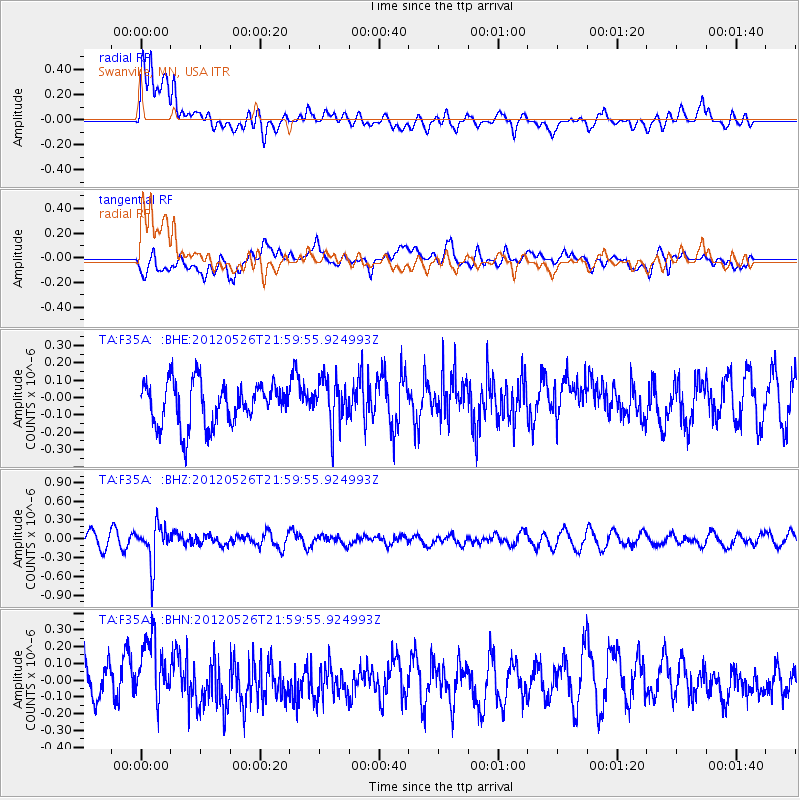
Signal To Noise
| Channel | StoN | STA | LTA |
| TA:F35A: :BHZ:20120526T21:59:55.924993Z | 1.9703151 | 3.0355048E-7 | 1.5406191E-7 |
| TA:F35A: :BHN:20120526T21:59:55.924993Z | 1.7180389 | 1.9936749E-7 | 1.1604364E-7 |
| TA:F35A: :BHE:20120526T21:59:55.924993Z | 1.0749606 | 1.3126372E-7 | 1.2211027E-7 |
| Arrivals |
| Ps | |
| PpPs | |
| PsPs/PpSs | |


