You are here: Home > Network List > TA - USArray Transportable Network (new EarthScope stations) Stations List
> Station C36A Pine Crest Fram, Angora, MN, USA > Earthquake Result Viewer
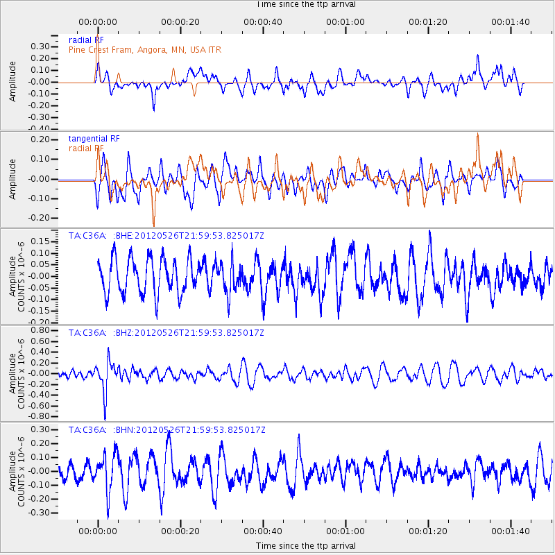
C36A Pine Crest Fram, Angora, MN, USA - Earthquake Result Viewer
*The percent match for this event was below the threshold and hence no stack was calculated.
| Earthquake location: |
Bonin Islands, Japan Region |
| Earthquake latitude/longitude: |
26.9/140.1 |
| Earthquake time(UTC): |
2012/05/26 (147) 21:48:10 GMT |
| Earthquake Depth: |
487 km |
| Earthquake Magnitude: |
5.5 MB, 6.0 MW, 6.0 MW |
| Earthquake Catalog/Contributor: |
WHDF/NEIC |
|
| Network: |
TA USArray Transportable Network (new EarthScope stations) |
| Station: |
C36A Pine Crest Fram, Angora, MN, USA |
| Lat/Lon: |
47.76 N/92.84 W |
| Elevation: |
410 m |
|
| Distance: |
91.8 deg |
| Az: |
32.573 deg |
| Baz: |
314.563 deg |
| Ray Param: |
$rayparam |
*The percent match for this event was below the threshold and hence was not used in the summary stack. |
|
| Radial Match: |
48.559822 % |
| Radial Bump: |
400 |
| Transverse Match: |
45.5205 % |
| Transverse Bump: |
398 |
| SOD ConfigId: |
446234 |
| Insert Time: |
2012-08-25 22:07:40.611 +0000 |
| GWidth: |
2.5 |
| Max Bumps: |
400 |
| Tol: |
0.001 |
|
Signal To Noise
| Channel | StoN | STA | LTA |
| TA:C36A: :BHZ:20120526T21:59:53.825017Z | 3.8464708 | 2.920191E-7 | 7.591871E-8 |
| TA:C36A: :BHN:20120526T21:59:53.825017Z | 1.6688299 | 1.3351412E-7 | 8.0004625E-8 |
| TA:C36A: :BHE:20120526T21:59:53.825017Z | 0.878398 | 6.533938E-8 | 7.438471E-8 |
| Arrivals |
| Ps | |
| PpPs | |
| PsPs/PpSs | |


