You are here: Home > Network List > TA - USArray Transportable Network (new EarthScope stations) Stations List
> Station H38A Maiden Rock, WI, USA > Earthquake Result Viewer
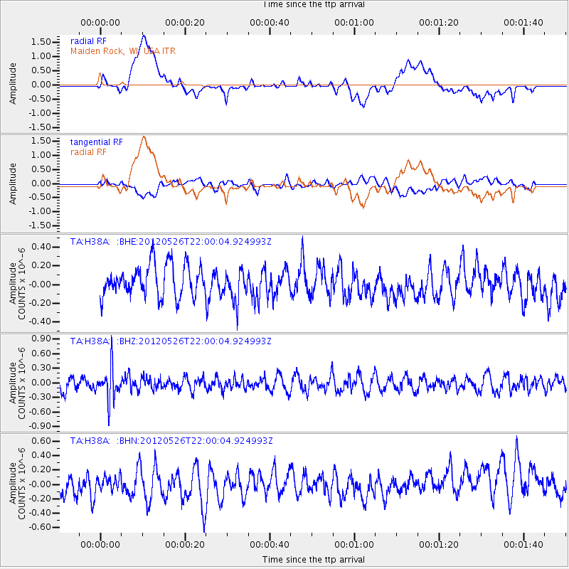
H38A Maiden Rock, WI, USA - Earthquake Result Viewer
*The percent match for this event was below the threshold and hence no stack was calculated.
| Earthquake location: |
Bonin Islands, Japan Region |
| Earthquake latitude/longitude: |
26.9/140.1 |
| Earthquake time(UTC): |
2012/05/26 (147) 21:48:10 GMT |
| Earthquake Depth: |
487 km |
| Earthquake Magnitude: |
5.5 MB, 6.0 MW, 6.0 MW |
| Earthquake Catalog/Contributor: |
WHDF/NEIC |
|
| Network: |
TA USArray Transportable Network (new EarthScope stations) |
| Station: |
H38A Maiden Rock, WI, USA |
| Lat/Lon: |
44.68 N/92.28 W |
| Elevation: |
333 m |
|
| Distance: |
94.2 deg |
| Az: |
34.495 deg |
| Baz: |
314.863 deg |
| Ray Param: |
$rayparam |
*The percent match for this event was below the threshold and hence was not used in the summary stack. |
|
| Radial Match: |
21.864424 % |
| Radial Bump: |
400 |
| Transverse Match: |
36.372677 % |
| Transverse Bump: |
400 |
| SOD ConfigId: |
446234 |
| Insert Time: |
2012-08-25 22:09:06.105 +0000 |
| GWidth: |
2.5 |
| Max Bumps: |
400 |
| Tol: |
0.001 |
|
Signal To Noise
| Channel | StoN | STA | LTA |
| TA:H38A: :BHZ:20120526T22:00:04.924993Z | 1.8111223 | 3.318877E-7 | 1.8324975E-7 |
| TA:H38A: :BHN:20120526T22:00:04.924993Z | 0.46651813 | 8.3996184E-8 | 1.8004913E-7 |
| TA:H38A: :BHE:20120526T22:00:04.924993Z | 1.0423076 | 1.7341344E-7 | 1.6637452E-7 |
| Arrivals |
| Ps | |
| PpPs | |
| PsPs/PpSs | |


