You are here: Home > Network List > G - GEOSCOPE Stations List
> Station RER Riviere de l'Est, La Reunion (Indian Ocean) > Earthquake Result Viewer
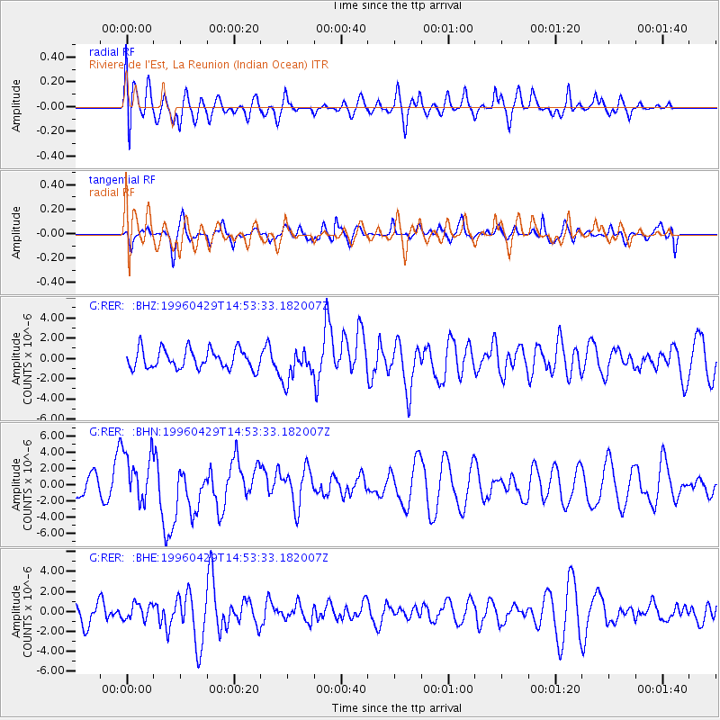
RER Riviere de l'Est, La Reunion (Indian Ocean) - Earthquake Result Viewer
*The percent match for this event was below the threshold and hence no stack was calculated.
| Earthquake location: |
Solomon Islands |
| Earthquake latitude/longitude: |
-6.5/155.0 |
| Earthquake time(UTC): |
1996/04/29 (120) 14:40:41 GMT |
| Earthquake Depth: |
44 km |
| Earthquake Magnitude: |
6.3 MB, 7.5 MS, 7.2 UNKNOWN, 6.8 ME |
| Earthquake Catalog/Contributor: |
WHDF/NEIC |
|
| Network: |
G GEOSCOPE |
| Station: |
RER Riviere de l'Est, La Reunion (Indian Ocean) |
| Lat/Lon: |
21.16 S/55.75 E |
| Elevation: |
834 m |
|
| Distance: |
96.2 deg |
| Az: |
247.932 deg |
| Baz: |
99.413 deg |
| Ray Param: |
$rayparam |
*The percent match for this event was below the threshold and hence was not used in the summary stack. |
|
| Radial Match: |
51.10716 % |
| Radial Bump: |
400 |
| Transverse Match: |
58.9924 % |
| Transverse Bump: |
400 |
| SOD ConfigId: |
4480 |
| Insert Time: |
2010-02-26 23:46:01.238 +0000 |
| GWidth: |
2.5 |
| Max Bumps: |
400 |
| Tol: |
0.001 |
|
Signal To Noise
| Channel | StoN | STA | LTA |
| G:RER: :BHN:19960429T14:53:33.182007Z | 2.723678 | 3.1196603E-6 | 1.145385E-6 |
| G:RER: :BHE:19960429T14:53:33.182007Z | 0.7573896 | 8.0339134E-7 | 1.0607372E-6 |
| G:RER: :BHZ:19960429T14:53:33.182007Z | 1.6621515 | 1.5821512E-6 | 9.518694E-7 |
| Arrivals |
| Ps | |
| PpPs | |
| PsPs/PpSs | |


