You are here: Home > Network List > CB - China National Seismic Network Stations List
> Station GOM Geermu,Qinghai Province > Earthquake Result Viewer
GOM Geermu,Qinghai Province - Earthquake Result Viewer
| Earthquake location: |
E. Caroline Islands, Micronesia |
| Earthquake latitude/longitude: |
6.5/144.9 |
| Earthquake time(UTC): |
2014/05/15 (135) 08:16:34 GMT |
| Earthquake Depth: |
10 km |
| Earthquake Magnitude: |
6.6 MWP, 6.6 MI |
| Earthquake Catalog/Contributor: |
NEIC PDE/NEIC COMCAT |
|
| Network: |
CB China National Seismic Network |
| Station: |
GOM Geermu,Qinghai Province |
| Lat/Lon: |
36.20 N/94.81 E |
| Elevation: |
3121 m |
|
| Distance: |
54.4 deg |
| Az: |
310.283 deg |
| Baz: |
110.425 deg |
| Ray Param: |
0.065462865 |
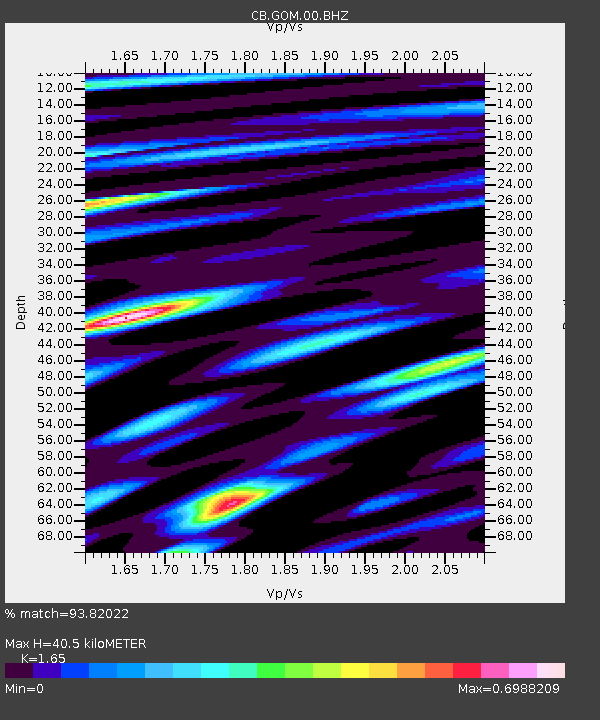
| Estimated Moho Depth: |
40.5 km |
| Estimated Crust Vp/Vs: |
1.65 |
| Assumed Crust Vp: |
6.385 km/s |
| Estimated Crust Vs: |
3.87 km/s |
| Estimated Crust Poisson's Ratio: |
0.21 |
|
| Radial Match: |
93.82022 % |
| Radial Bump: |
400 |
| Transverse Match: |
83.20106 % |
| Transverse Bump: |
400 |
| SOD ConfigId: |
3390531 |
| Insert Time: |
2019-04-11 21:32:41.170 +0000 |
| GWidth: |
2.5 |
| Max Bumps: |
400 |
| Tol: |
0.001 |
|

Signal To Noise
| Channel | StoN | STA | LTA |
| CB:GOM:00:BHZ:20140515T08:25:32.119983Z | 2.2379801 | 1.4394435E-7 | 6.431887E-8 |
| CB:GOM:00:BHN:20140515T08:25:32.119983Z | 1.1718088 | 5.8495395E-8 | 4.991889E-8 |
| CB:GOM:00:BHE:20140515T08:25:32.119983Z | 1.62169 | 4.795812E-8 | 2.9572925E-8 |
| Arrivals |
| Ps | 4.4 SECOND |
| PpPs | 16 SECOND |
| PsPs/PpSs | 20 SECOND |


